• Updating Nordweststadt

    Like many other residential schemes of the 1960s the Nordweststadt in Frankfurt requires an update of its building stock, a redesign that meets current and future demands of urban living. A set of transferable, integrative, and low-cost design measures is developed, focusing on three main tasks: Tidying up, the regeneration of neighbourhoods, and the strengthening of identity.

    Shrubs and trees are cut back, the parking is reorganized, pedestrian and cycle lanes are being introduced, new public spaces are designed and the courtyards are upgraded by private gardens, new public green amenity spaces and 'light pergolas' - a minimal architecture that connects basement parking with the courtyards and passes over into a podium with seating steps on ground level. The light pergolas enclose a small lounge, an external barbecue, water and electricity connections and a bicycle workshop. During evening hours and at night the pergolas illuminate the courtyard, by day these enable diverse and easy use of the courtyard and strengthen a lively community.

    completed
    2010-2014
  • TXL Restart. Integral Systems

    The airport Berlin Tegel is going to be closed down. TXL will be developed as a high-quality research, industry and business park with the profile of 'urban technologies'. A strategic master plan builds the foundation for a flexible - and therefore, robust - planning process. Developmental guidelines and a profound system of rules create a structural, programmatic and creative quality of strategic important subareas.

    Simultaneously, more flexible developmental options are being allocated for other areas. ‚Quarters' profiles' emphasize existing potentials of subareas and strengthen the specific identity. An integrated concept for energy and water supports sustainable development: biomass, geothermal energy, wind energy and photovoltaics provide regionally generated energy. Gray and rainwater is being collected, refined and reused regionally. An urban aerial railway connects the site with the station and the tram. Here, the aerial railway is not only an efficient, sustainable means of transport but also represents sustainable mobility in terms of the site's profile.

    completed
    2012
  • Park City

    The project is located on the western outskirts of Tirana, an area which has seen major development in recent years due to its prime location close to the main entrance corridor to Albania's capital. With a total of approx. 400.000 m2 built floor area the new district will house approximately 7.000 inhabitants. It stretches between two large parks, whose conceptual design also formed part of the competition brief. Runway Park is a 1,1 km long former landing strip and Lana Park is an extension of the city's main green axis. The design proposes an urban layout that forms a hinge between these two parks, making them accessible, as well as connecting them, whilst strengthening the distinctively different character of both. The urban structure reflects a combination of three typologies: 4 storey stripes, 12 storey towers and 8 storey 'urban rocks'. The aim is to offer a broad variation of lifestyles, as opposed to the prevalent development paradigm of 9 storey broken perimeter blocks in Tirana.

    completed
    2009
  • Urbanizing the Periphery. Munich

    The study "periphery | landscape" identifies potentials and gives strategic advice for the long-term spatial development of the north-eastern periphery of Munich. The team was asked to work out a strategy for the development of an area of about 350 ha and to specify their findings for a sample size of around 150 ha.

    The approach is based on the following steps: The potentials of the area are recognized in a profound analysis and brought together in a synthesis map (A). Challenges concerning sustainable development in the periphery were discussed. They led the team to five strategies (B). These strategies provide a framework for long-term spatial development. They were developed in a close interplay with the design of a spatial vision for the North-East of Munich (C). The spatial vision shows ideas for future open spaces and new developments. The team invented a set of typologies of periphery settlement. The typologies focus on specific combinations of settlement and open space (D). A design for the sample site (E) is differentiated with stories, best-practice examples and development options in order to illustrate the everyday life of future inhabitants.

    completed
    2011
  • Perspectives Gütersloh

    Over the past decade, many gaps in building blocks have been closed in the city of Gütersloh. Various areas have been upgraded or restructured. With the integrated action plan, not only the urban design of the city will be further sharpened. With the participation of diverse actors, new prospects for the long-term development of the city are presented.

    Strategic decisions are prepared to make the city centre adaptable for changing spatial requirements in the future. The integrated action plan defines key objectives for development. Conceptual and design requirements are defined for e.g. functional mix, open space planning, or traffic issues. These recommendations are implemented and spatially located in a strategic master plan. On this basis, future developments and project proposals can be tested and evaluated and individual measures can be derived.

    completed
    2013
  • Perspektivplan. Spatial Vision Freiburg

    Freiburg is a growing city where more and more people want to live. How can the city continue to be developed in a sustainable way? The Perspectivplan elaborates spatial development options for the City of Freiburg in the next 10 to 15 years. In the course of designing, built-up areas and open spaces are conceived and developed together. Based on a differentiated (GIS)-structure analysis, so far undetected potentials are made visible, development strategies are pointed out and by means of scenarios a future spatial image with a complementary structure plan is generated. The project has been developed in a cooperative process with stakeholders, the municipality, politics and the public.

    www.perspektivplan-freiburg.de

    completed
    2017
  • Cradle-to-Cradle Industrial Park

    The concept Cradle-to-Cradle (C2C, Michael Braungart et al.) is based upon the idea of a circular economy in which resources are not consumed but are continually used. The feasibility study explores how this concept can be transferred to the development of industrial parks: C2C-principles for the design of buildings, open spaces and infrastructure are developed and a structural plan for a test site in Bielefeld, Germany, is laid out.

    Moreover, an energy system for the whole area is designed and C2C-prototypes for buildings and open space situations. The approach of the study is holistic and interdisciplinary and its planning recommendations can be used for the development of new industrial areas as well as for the transformation of existing sites. The study is part of the INTERREG-IVB project „Cradle to Cradle Business Innovation & Improvement Zones. C2C-BIZZ". Please contact us for the entire feasibility study.

    completed
    2014
  • Zhuhai Floating City

    Zhuhai is growing. The challenge now is to make this growth consistent with landscape and waters against the backdrop of climate change. The aim is to minimize the intrusion in nature due to ecological and economical reasons and by doing that to create a high quality of living in the city.

    The sponge city principle provides a convenient strategy for this purpose. Diverse water systems for the regulation of tides, flooding rives and heavy rains are not only integrated into the city structure but also utilized to provide various leisure and recreation facilities. In Combination with the local landscape and water characteristics, the sponge city principles shape a unique cityscape. In order to do that the project develops a city typology and various waterfront strategies which are transferable and versatile tools for future urban planning.

    completed
    2016
  • Yueyang. Better water - better city

    Yueyang is a growing city in the Chinese province of Hunan. In cooperation with hydrology, water management, and water ecology experts as well as landscape architects, we developed a masterplan with the aim of a new adjustment of urban and open space development in the course of water quality improvement.

    The masterplan analyses the spatial and programmatic potentials of the Nanhu (lake) and the surrounding build-up and open space structures and develops them as a blue-green infrastructure. That improves the city's interconnectedness and the accessibility of green spaces. A catalogue of sponge city strategies proposes transferable concepts for a structure related integration of sponge city principles. The blue-green-black masterplan merges the strategies and delivers design approaches for different types of waterfronts and city profiles.

    completed
    2016
  • Perspective Holzwickede

    For the growing city of Holzwickede, a long-term development concept is elaborated. The brief was a model for the overall city area and the definition of several urban development zones, with will be the focus of future city development. The recommondations for action are further concretized and located in a planning framework.

    The strategic project process starts off with spatial, social and historical analysis, then describes area profiles and development goals and strategies. Zoom-ins of the focus zones show more contrete provisions and exemplified spatial strategies.

    On the basis of the integrated action plan and the strategic development chances, processes can be verified, evaluated and arranged in the future, such as individual actions can be derived.
    The integrateted action plan is accompanied by a civic activism process and cooperation with the local goverment.

    completed
    2016
  • The multimodal City / Transformation Freeway B3

    Alternating the inner-city freeway B3 offers chances of enormous quality. In place of a disruptive gap with high infrastructural means, a continuously livable city can emerge along the freeway. A city that is balanced multimodally with all its functions, spaces and atmospheres. The integration of transit spaces as well as thinking built environment and free space together enables a programmatic diversity and synergies which can react to change. Besides the task of keeping up the traffic flow, barriers, noise and emissions are being reduced and inner-city plots are being reclaimed for urban developments.

    The chosen street section in the "Leinemasch" minimizes the intervention in the landscape. The Willmerstrasse is being transformed into a lively city street with high living and sojourning qualities by implementing a tunnel for the freeway, starting from Schützenstraße. East of the Hildesheimer Straße a Tunnelpark emerges with high qualities of open space for the adjacent urban areas. In addition to optimizing the freeway itself, sustainable mobility and transport are being valorized massively: Ricklingen in the west and Döhren in the east are connected with a bicycle highway and a tangential busline.

    completed
    2015
  • Grand Standing. Urban Centre Berlin

    The building's structure is based on the static elements pillar, plate and gate as well as the every few minutes incoming trains. A natural passage from Luckernwalder street to the signal box and the park connection south is build up by the viaduct facades of lines U2 and S21. They could easily be activated by contemporary commercial usage for the traffic centre "Heart of Stations".

    In sum, a unique specimen is generated, creating a special atmosphere and spatial quality between the tracks and towards the park. In the north-south direction, the slender, 17-storey superstructure is extended over the property. It is adapted as a rostrum and stage to the park and fits into the heterogeneous property structure between ICE lines and stations. In the base area, four gates allow the train transits and significant visual references in north-south as well as in east-west direction. On the various levels, " heavenly" spaces for non-commercial transit and temporary users are integrated into the structure of established users and anchor tenants.

    completed
  • Open Neighbourhoods

    This urban design aims to create an attractive living environment for young families and couples and to give a new impulse to a large social housing estate from the 1960s. The existing open block structure will be maintained but is transformed into a structure with semi-private courtyards.

    Different typologies - i.e. houses with ground-level access, apartments with open floor plans - add variation to the housing supply. Within the building blocks, elevated courtyards create a safe environment for social interaction between inhabitants, especially young families. Notwithstanding their open character, these courtyards offer a clear visual and functional border between public and private spaces.

    Between the blocks, a sequence of car-free squares that draw on the surrounding structure contributes to a lively public space. To keep spaces as car-free as possible, most of the parking is organized in underground garages which are accessible from the edges of the block. By drawing on the existing structure, and by continuing the green belts and the existing rows of trees, the design creates a strong link with its surroundings.

    completed
    2016
  • District Landscape Dietenbach

    How does a newly developed city district become a vibrant place to live?

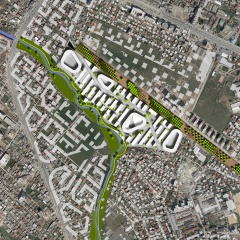
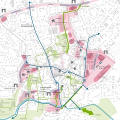
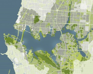
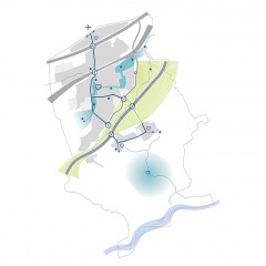
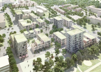
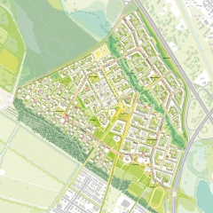
    The characterful landscape of Freiburg with the surrounding Schwarzwald serves as the decisive basis for the newly designed district Dietenbach. The four emerging quarters will be connected by a ring boulevard. In contrast to the generous open spaces, which serve as decelerated exercise and relaxation areas and make a significant contribution to nature and species protection, pulsating life takes place here. The new city centre serves as a bracing supply center and community reference point with symbolic centrality. In addition to the 5,500 residential units, new jobs and schools will be created in the 108-hectare area, which will complete the new living environment.

    Integration into the urban, functional, and landscape context
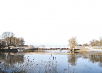
    The new district Dietenbach is structured by the iconic landscape, especially the eponymous Dietenbach.

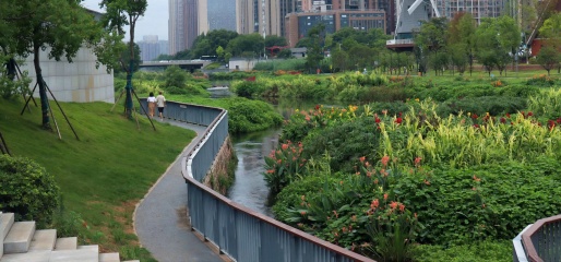
    The resulting open spaces ensure the supply of fresh air and a stable microclimate. The former course of the Käserbach river has been reactivated and serves as partially communal garden land. In the region of ​​the school and sports campus, this zone also includes play, sports, and recreation areas that can be used by the public.

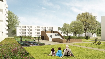
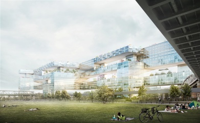
    In contrast to this, the new centre of the district as a communal supply center offers space for weekly markets, city festivals, outdoor areas for restaurants, and water features. There are also retail stores, gastronomic offers, and services. The building plots of the compact quarters address different market segments. A large number of construction site sizes, building heights, building types, and locations provides a large typology mix and thus offers a lot for different target groups.

    Mobility concept
    The mobility concept pursues the goal of reducing motor vehicle traffic, car ownership, and the number of parking spaces. This makes an important contribution to an attractive living environment, affordable living space, and environmentally friendly transport. It is achieved by creating attractive offers for pedestrian and bicycle traffic, public transport with light rail, as well as offers for car sharing and e-mobility, and also by parking in district garages in less sensitive locations that are up to 200m away from the apartments.


    completed
    2018
  • Revitalizing Guitanghe

    The river Guitanghe in its current state holds complex problems for the urban development of Changsha. In the future, it is to be identified as a central and living lifeline in the city and its ecological, urban, social and cultural significance will be considerably increased.


    Based on a flood problem and different water levels of the Guitanghe, dynamic urban development is created that considers water as a variable in dimensioning and programming of spaces. In this urban experimental field, innovative economic and urban development concepts intermesh. Changsha, a growing city, gets an ambitious, positive and future-oriented perspective.


    The river is going to play a major role as the central and linear centre of the city and, in addition to water management measures, offers the opportunity to make urban improvements and to connect Changsha via green and blue veins emanating from the river, both within the city and outwards. The Guitanghe will work as a green lung and strengthen the urban ecosystem as well as it will provide the city of Changsha with a new identity through local recreation areas and social and cultural infrastructure.

    completed
    2019