• Life in Sandbachpark

    SUFFICIENT, DIVERSE, CIRCULAR

    The competition area is the first step in the restructuring of the existing commercial area into a mixed-use residential quarter. Between the cultural axis with a new metro connection in the north and the Sandbach with the future development of a park in the south, the area offers potential for a lively quarter with added value for residents, nature and the neighborhood with open spaces, buildings and services that can be used in a variety of ways. The design is based on a compact urban development that conserves the valuable resource of land and offers space for nature, rainwater management and leisure uses. The unsealed surfaces enable lush vegetation that promotes biodiversity, generates a balanced microclimate and creates atmospherically strong places. To promote the local rainwater balance, rainwater is retained on site, infiltrated, evaporated or stored in cisterns to irrigate plants. A diverse mix of uses including living, working, supply and leisure facilities creates a lively, „complete" district and reduces the need for mobility. A multimodal mobility offer organized in the neighbourhood garage consisting of sharing and e-mo-bility offers, cargo bikes, bicycle trailers, etc. reduces the space required and enables the cost-effective use of current technologies. The sufficiency district approach also reduces individual ownership in favor of shared prosperity, thereby conserving the planet's resources. Flexible (timber)system construc-tion and compact building volumes enable cost-effective construction. The sustainable building materials used, such as wood, clay, straw, etc., are used so that they can be decomposed by type. The necessary energy is generated locally as far as possible - PV on roofs and some facades, as well as geothermal energy, are used.

    Idea
    2024
  • Münster-Hiltrup Ost

    BLUE-GREEN NEIGHBOURHOODS

    The design taps into the potential to create a green, climate-adapted and carfree district for Münster Hiltrup that blends harmoniously into the existing landscape and settlement structure. Four compact neighborhoods with a large contact area to the open space will be linked by diverse green corridors in the interior (Green Delta) as well as a close-knit network of cycle paths and footpaths and attractively connected to the outside. Motorized traffic is reduced to a minimum and parking spaces are bundled. Within the neighborhoods, the mobility hubs form everyday hubs. A small-scale, differentiated development structure with ground floor uses at the neighborhood squares, social functions and various, mixed typologies suggest a people-centered scale with a rural character. In conjunction with an innovative climate adaptation concept and high ecological and energy standards, a future-oriented neighborhood development is being created for Hiltrup.

    Rainwater management follows the principle of the sponge city with the aim of minimizing intervention in the natural water balance, achieving near-natural rainfall-runoff behaviour, ensuring sufficient purification of the surface runoff that occurs, preventing flooding in the settlement area and reducing the runoff peaks into the watercourses to a natural level. Implementation is carried out as far as possible using near-natural methods with a small proportion of technical structures. In addition to the purely water management aspects, ecological benefits such as increased biodiversity and heat reduction are achieved. At the same time, blue-green structures are created that allow residents to experience the element of water.

    Idea
    2023
  • Masterplan Nové Dolíky, Slany

    How can we create a modern suburban environment suitable for pedestrians in a 15-minute neighborhood - a new district with its own urban character that can withstand the ever-increasing pace of changes in human society?

    This is achieved by creating a car-free district that emphasizes pedestrian and cycling transportation, designing compact development that forms both a clearly defined public space and an attractive living environment for future residents.
    The concept of approaching public spaces stems from the fundamental idea of relocating cars to the outer edges of the development. The majority of parking spaces are condensed into three mobility hubs on the corners of the site. The implementation of blue-green infrastructure and the provision of quality public space for the residents of Slaný form a better connection between an agricultural park in the west to the city center in the east. With all amenities within reach and accessible recreational areas, the neighborhood will ensure a healthy and sustainable living environment.

    Part of this design is the establishment of a central green axis, functioning as a retention valley and providing space for trees and biodiversity. It directs the outer landscape and waterflows into the new neighborhood and results in the
    creation of a vibrant blue and green boulevard featuring diverse private and public spaces.

    The urban structure that forms this proposal has been carefully crafted to create compact development with a diversity of typologies and financing models. It is also based on simplicity and elegance for sustainable and prospective construction methods, along with a reliable approach grounded in a connection to nature.

    Idea
    2023
  • Biotech Archipelago Mainz

    The Bio-Tech Archipelago is a great opportunity for the city of Mainz to build on its global reputation in the biotechnology sector and at the same time develop a city for everybody. Here, optimal conditions for research and development are combined with housing, leisure facilities and a vibrant landscape for people and nature. The design focuses on favoring cooling wind currents, networking local biotopes and preserving the expansive landscape and thus fullfill the requirements of the sensitive urban location and the associated responsibility for our environment.

    Located as a gateway to the city on Saarstrasse, it communicates structurally, spatially and programmatically between the cultural landscapes of the outskirts of Mainz and the biotech axis. It is both the entrance and keystone of the westward expansion of the city and generates a variety of added urban ecological values and offers for the local environment and the city as a whole. The urban figure opens up to the open landscape in spacious corridors. The building mass is divided into four sub-areas that unite to form a flowing archipelago-like urban landscape around a common open space.

    Idea
    2023
  • Marienburger Strasse

    The focus of our project is, on one hand, the careful urban integration of approximately 43,000 m2 GFA (realization part) and 10,000 m2 GFA (conceptual part) of dense housing into the existing morphological and ecological context, taking into account imposed restrictions and desires. On the other hand, the identity of our project arises from intense coordination and integration of urban planning, architecture, ecology, and landscape design.

    Characteristic of the existing urban structure of the broader surroundings of the competition area is the loose construction with small and medium-sized structures. In contrast to this morphology, the future urban fabric east of the railway track is planned as an urban densified perimeter block structure (Munich Northeast Ideas Competition). Our project establishes a context-related connection to these two different spatial conditions while simultaneously creating its own strong local identity.

    To achieve this, our design is structured into overlapping levels of order, creating differentiated and precise spatial relationships: The construction structure is divided into four typologies. In the west along Marienburger Strasse, the existing structure of rowed, rhythmically offset, small-scale buildings is appropriately complemented to ensure spatial permeability. This is followed by a loose sequence running north-south of individual building volumes (urban villas) increasing in mass and height, set in a landscape park-like arrangement. A third row consists of elongated structures on the east and north sides, which are more monolithic and taller in the northern part, gradually transitioning to a sequence of architectural individual units towards the south.

    completed
    2023
  • The Brandenbusch-Eck

    A new entrée to the Villa Hügel

    Based on the design principle "Landschaf(f)Stadt", the new Brandenbusch-Eck is a forward-looking and iden-tity-creating entrance to the Brandenbusch neighbourhood and the Villa Hügel in Essen. A neighbourhood that is being developed sustainably and serves as a centre of life for a broad range of residents. A small-scale and diverse density creates a lively place, uses resources sparingly, utilises infrastructure efficiently and relies on the mobility of the future - eco-mobility.
    Building on the strong scenic framing of the Brandenbusch neighbourhood by the Kruppwald forest and the preservation of valuable biotopes and existing trees, the "green carpet" completes the new entrance to a closed biotope network. This public green space is designed as an inviting gesture to the Hügelpark and the Villa Hügel itself.
    Brandenbusch-Platz, as a publicly effective square and protected new centre, links the new neighbourhood with the existing listed estate and promotes interaction. A new connection is created at the usage level: the social and cultural facilities in the neighbourhood are placed in a new context by the design. The connection between the church and the school is created by the Brandenbusch corner.

    Idea
    2023
  • Theoretikum Halle - Der adaptive Campus

    Closing the gap between the university hospital in the north and the biotechnology campus in the south, the THEORETIKUM complements the science and business location in the north-west of the city of Halle an der Saale. The development site is simultaneously integrated into the urban space, functionally connected to the research and teaching facilities and integrated into the landscape. The proposed concept sees itself as a gradually growing, learning and responsive campus that integrates the existing and takes a holistic view of the new. With innovative research and technology clusters, attractive teaching and learning facilities as well as new service and communication areas, functions are bundled, synergy effects are created and potential for supra-regional impact is generated. As an adaptive campus, the THEORETIKUM is more than its individual clusters.


    The urban structure is formed by the campus loop as an address-giving backbone, a functional overlay of the clusters, building plots with adaptive development options and the integration of landscape qualities. Buildings with independent appearances (old - new, small - large, flat - high, square - rectangular) fit together playfully and, along with the uniform open space design, form a versatile, coherent overall picture. The slightly twisted structures create interesting and surprising room sequences and integrate existing elements (buildings, trees, paths) during the various expansion stages. Three existing high-rise buildings will be retained in the long term as a highly visible ensemble and will be integrated into the campus development.
    The northern entrée forms a counterpart to the UKH and is visually and functionally linked by the redesign of the junction. The pandemic center as the first building block is set back slightly and, together with the campus kiosk, conveys the leap in scale from the existing high-rise building to the loose residential development in the surrounding area. The southern entrance is designed at the mobility hub with an active ground floor. The technology and research centers will be realized as compact building blocks with inner courtyards or atriums and base floors. The active heart is formed by the service and communication center at the intersection of the urban north-south and green east-west connection.

    Idea
    2023
  • Waldstadt Jüchen

    From an Mining Hole to climate-positiv urban destrict

    The Jüchen South urban planning competition deals with a largely unanswered question: How do we want to deal with the post-mining landscape? And in particular: What does a settlement look like that is built on such an area? Do we leave it at the legally stipulated reclamation and pursue settlement development on a greenfield site? Or do we try to live up to the responsibility that comes with urban development and use the opportunity to make a fresh start, to make amends and to mitigate the damage done to the landscape and the global climate?

    Our contribution formulates a district as a symbol of this new beginning and an exemplary path for the future. It is based on the circular bioeconomy as an innovative economic model. Based on circular principels, the concept focuses on the sustainable value creation of local resources, especially soil, and thus creates the basis for an attractive and healthy living environment. The concept envisages laying the foundation for a new cultural landscape in Jüchen - the Jüchener Stadtwald - on the artificially created landscape area of the former open-cast mine. This forest forms the landscape architectural foundation for the settlement development, has top priority as an efficient ecosystem, is the basis of a sustainable healing process and a central element of the circular economy. It stores CO2, provides climate-positive building materials and food, produces energy, functions as a sponge forest and retention area, protects against noise, wind and dust and offers diverse leisure and local recreational functions. The urban forest in its various typologies forms the economic, urban structural and identity-creating basis of the new urban district.

    Idea
    2023
  • Bremen Könecke Areal

    Hemelingen on the move - A new urban neighborhood Könecke-Areal

    The revitalization and reintegration of inner-city industrial areas is one of the most important planning tasks of the day. These areas are usually excellently developed in terms of infrastructure, which supports sustainable development, and can save a lot of gray energy. Complex ownership, emission sources and soil contamination are challenges that require innovative, robust and flexible urban planning concepts. The design takes advantage of the unique opportunity to free the area from its infrastructural island location in order to reconnect the districts of Hastedt, Seebaldsbrück and Hemelingen by building an urban bridge. Together with the southern (former) Coca-Cola site, which was part of a former urban design process, it forms the new center of Hemelingen.
    The vacated areas will provide what the district needs now and, in the future, - that is an affordable and diverse housing mix, adaptable spaces for working, learning, leisure and culture, but above all it is urgently needed public green space. The new neighborhood park forms the green heart of the entire district and creates a strong address to the future premium bike route that will connect the neighborhood with the center of Bremen.

    Idea
    2023
  • Ludwigsfeld München

    Like a coat, the development wraps itself around the greened-out Ludwigsfeld estate. It does this conceivably loosely and discreetly over open spaces. The dissolution of grains and densities of use is small-scale in relation to the existing buildings and protects them from noise at the edges.

    The concept proposes four different urban building blocks to complement the Ludwigsfeld settlement: green residential courtyards, active neighborhood houses, a cautious addition to the existing buildings, and flexible neighborhood garages.
    Through compact and green residential courtyards with a diverse appearance, a variance in the number of stories and vertical greening, the targeted density is achieved with high residential and open space quality. In relation to the existing buildings, the residential courtyards dissolve into an open development, which also adapts in terms of the number of stories and mediates via community gardens.
    Four neighborhood houses at a central location in the neighborhood link the living with base areas for supply, social facilities and community uses. As project building sites, special forms of housing can be implemented here in alternative development models. Through a striking design and the active ground floor areas, they are crystallization points in the public space.

    The design supports the goal of a sustainable and CO2-neutral neighborhood development. The infrastructures required for the planned energy concept are integrated into the urban design and areas for energy generation are demonstrated accordingly.

    Idea
    2023
  • Parkway Heidelberg

    „Think about people first, then about traffic routes. A good city is like a good party. People stay there longer than necessary because they feel good." This quote from Danish urban planner Jan Gehl sums up our planning understanding of the Parkway well.

    The Parkway is a place that is finely networked, that relates building and open space uses in a variety of ways, and that actively supports climate resilience. A green and diverse space that constantly links the opposites of MOBILITY and DISTURBANCE. Due to the valuable and spatially defining existing trees in the Patrick Henry Village as a starting point, the route was designed in such a way that as many woody plants as possible are preserved. Rainwater is stored in swales, infiltration trenches and rain gardens as a valuable resource, benefiting plants and groundwater. The paved areas are reduced to a minimum and designed as light-coloured surfaces.

    The paving material is a newly developed and market-introduced climate stone which absorbs rainfall and can evaporate as much water as a meadow surface (50% instead of 11% to 18% as with conventional paving stones).
    The Parkway fulfils the function of a linear park with a high quality of open space, encounter and stay, serves as an inner and outer distributor for the Patrick Henry Village and provides a safe framework for a broad variety of urban mobility types.

    completed
    2023
  • MAGNUM-Areal Osnabrück

    The Magnum site's DNA of industrial heritage and landscape succession forms the starting point for the transformation into a climate resilient neighborhood. The unique character of the former steelworks is expressed spatially in the overlapping of the scales of human, machine and nature and of the atmospheres between narrow alleys and wide squares.


    This productive interplay continues to write the history of the Magnum site in constant change. Three subspaces (water courtyards, forest campus, factory cluster) derive from the site, each with its own independent profile, which form synergies with each other and with the neighborhood. The Magnum Mile connects the three subspaces as a lively backbone of the quarter and the adjacent urban spaces to the west and east.


    For the quarter, own systems for the handling of water and soil are developed. They will be used for irrigation, gray water utilization and cooling of the quarter. The goal is to minimize erosion and soil exchange. As much accumulating water as possible is to be collected, filtered and reused. To do this, it will be stored in building-integrated cisterns. Materials collected are reused as much as possible. Existing structures, such as the grove or also hall structures are integrated and the character of the open space and the building structures are developed. The transformation is designed as a gradual, learning and appreciativ process.

    completed
    2023
  • Max-Becker-Areal

    The 17,3 ha site is currently isolated from the urban space and polluted with emissions. The environment is characterized by deficits in the open space and local supply with green spaces and represents a structural and programmatic caesura in the otherwise small-scale district structure of Ehrenfeld.

    With the „Best-Of Ehrenfeld" an open quarter with a strong character is created, which combines a high urban density with open, diversely networked and richly programmed open spaces. It is a Cologne Veedel (Kölsch for „quarter") in the best sense of the word: living, working, culture and education are fused in small spaces and linked with each other over short distances. The mix of uses is derived from the urban planning concept at the construction site level. The new district is green, culturally anchored and creatively attractive.

    The urban development forms a structural and programmatic bridge between the districts of Ehrenfeld, Müngersdorf and Braunsfeld. Urban density and diversity meet a green network with a wide range of offers and possible uses.

    in progress
    2023
  • Köpenicker Gleislandschaften

    The development of the former freight station Köpenick offers a unique opportunity to create urgently needed living space and jobs in a central, well-connected location in the immediate proximity of diverse natural landscapes. The major challenge here is dealing with the noise emitted by the railroad tracks, the industrial activity, but also the new eastern ring road.

    An open space ribbon links the area with its surroundings, takes over important climatic functions and crosses the neighborhood with public open space uses. An elementary part of the band is the undeveloped area in the north-east along the tracks, which leads the forest into the quarter and is a local recreation area and important retreat for flora and fauna. Noise protection typologies oppose the noise sources in the area and form an urban noise protection. This allows for a quiet neighborhood core with quality housing, quiet open spaces, and working environments. Uses evolve from the surroundings and respond to the differentiated context. This creates new synergies and promotes a functioning neighborhood.

    The „Köpenicker Gleislandschaften" transform the former freight station into a diverse, mixed and sustainable urban quarter, creating a strong edge at exposed locations and high-quality living in the inner neighborhood.

    Idea
    2022-ol23
  • Revitalizing Peja's River-Kosovo's Green Corridor

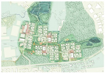
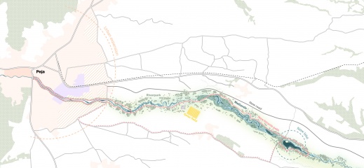
    The entire program consists of roughly 4 components: The City Green Spine, The River Park, Natural Wetlands, and The Multi-purpose Lake.

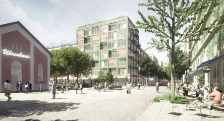
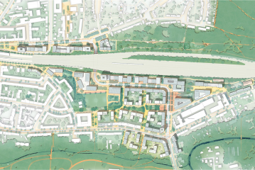
    City Green Spine aims to provide blue-green solutions for the city of Peja surrounding the Lumbardhi river. The main feature is a green, gradually-stepped riverbank, allowing access to the river and a green space adjacent to the center of Peja.

    The River Park is the section between the city and the newly built wastewater treatment plant. More specifically, it connects with the new urban development area of Peja. The River Park has a twofold aim: (1) manage the river, and (2) provide a green, natural environment for residents and tourists.

    The Natural Wetlands is the section of the river from the wastewater treatment plant to the lake. It is an area that will be more natural than the River Park, which allows the river to move more freely.

    The Development of the Multi-purpose Lake is one of the prestige measures of the program. The current site is degraded due to illegal gravel extraction and pollution. The Multi-purpose Lake will revitalize both socio-economic and ecological values of the site, whilst attracting national and international visitors.

    Connectivity of the urban and rural landscape is essential for accessibility and use of the to-be-developed program components. Measures include hike paths and bike paths from the city centre to the Multi-Purpose Lake, via the River Park and the Natural Wetlands. Lastly, a shuttle service will be developed to ensure easy transit between the city centre and the lake.

    Idea
    2022-2023