• Max-Becker-Areal

    The 17,3 ha site is currently isolated from the urban space and polluted with emissions. The environment is characterized by deficits in the open space and local supply with green spaces and represents a structural and programmatic caesura in the otherwise small-scale district structure of Ehrenfeld.

    With the „Best-Of Ehrenfeld" an open quarter with a strong character is created, which combines a high urban density with open, diversely networked and richly programmed open spaces. It is a Cologne Veedel (Kölsch for „quarter") in the best sense of the word: living, working, culture and education are fused in small spaces and linked with each other over short distances. The mix of uses is derived from the urban planning concept at the construction site level. The new district is green, culturally anchored and creatively attractive.

    The urban development forms a structural and programmatic bridge between the districts of Ehrenfeld, Müngersdorf and Braunsfeld. Urban density and diversity meet a green network with a wide range of offers and possible uses.

    in progress
    2023
  • Closed loop quarters. Between Frankfurt and Taunus

    CITYFÖRSTER has been unanimously selected for the design for the "Stadtteil der Quartiere" (district of the quarters)" in Frankfurt am Main, Germany with a concept that combines urban growth with circularity.

    The central challenge was how to create up to 10,000 apartments and 8,000 new jobs in an agricultural area on the northwest outskirts of Frankfurt, without losing the scenic qualities of this area. At the same time, the design also had to take into account various challenges; for example, like many peripheral metropolitan areas, the region is intersected by infrastructure - of which the six-lane Autobahn A5, which effectively divides the study area in two, has the greatest impact. A situation that is by no means exclusive to Frankfurt or even Germany, but can be found in most cities.

    One of the most remarkable choices was to keep 75 percent of the study area undeveloped, thus preserving the landscape and the connection to the Taunus. The design, which is based on the "Landschaf(f)tStadt" principle, consistently takes the possibilities offered by the landscape and the open space as a starting point.

    In order to protect as much of the landscape as possible, the development was kept in compact areas. This means, for example, the abandonment of single-family houses and the planning of mostly apartment complexes of five to six floors, occasionally even higher buildings. The underground and city railways form the backbone of the new districts; the expansion area "Steinbach-Ost" is directly connected to the existing S-Bahn line, and in the districts east of the Autobahn the metro network is being expanded. A number of the neighbourhoods will be car-free.

    The aim is to create circularly organized neighbourhoods - neighbourhoods as part of a cycle, in which they make an important contribution to water management, energy, and food supply, that promote environmentally friendly mobility, that regulate the climate and that enhance biodiversity - while naturally offering space for social exchange, providing a home to the community.

    All facts at a glance:

    4 new residential areas
    up to 10,000 apartments
    up to 8,000 new jobs
    5 schools
    20 nurseries
    47 hectares of public green within the neighbourhoods
    425 hectares of study area
    75% of the study area remains undeveloped

    completed
    2021
  • ecovillage Hanover

    With the development of the ecovillage in Hanover, there is a great chance to make an important contribution to future-oriented urban development. One of the most specific features of the ecovillage, and its guiding principle, is sufficiency. To possess more by sharing more: a highly flexible approach that, here, is not only preached but also practiced. In addition to a co-working space and several workshops, ecovillage also offers common rooms in the buildings and gardens that belong to and can be used by everyone, and there is even a special guest house for visitors to stay the night.

    The nucleus of the urban design is the lively village square, that is surrounded and framed by the commons. This is the green heart of ecovillage; where water is being managed, food is being produced and the spirit of community is being lived.

    One of the drivers for the development was the ambition to become a CO2-neutral settlement. Everything is built from wood, and the sealing of the surfaces is being minimized as well. Biodiversity is promoted and gray- and rainwater are treated and cleaned with the help of a plant-based sewage treatment system. After being directed into a biotope-like lake, it seeps away and evaporates, or serves the residents to water their gardens.

    The mobility concept also sets high goals with regard to future viability: it focuses entirely on local mobility. (local public transport, as well as pedestrian and bike path traffic). In concrete terms, this means only 0.2 parking spaces per residential unit are provided. In return, however, there are generous areas for bicycles, rental stations, handcarts, etc. A direct connection to the light rail system rounds off this concept.

    The neighbourhoods, which are connected to each other and to the centre by the commons, consist of differently sized clusters. These clusters comprise various building typologies, which in turn provide space for a wide range of apartment forms. This 'democratic' housing mix promotes social integration and creates strong neighbourhoods.

    ecovillage can be regarded as a pioneer in a long-overdue discussion of principles in which frugality is pursued as a philosophy.

    All facts

    500 residential units
    900 inhabitants
    5 hectares total area
    2 hectares of garden land
    3100 m² of commercial space
    2500 m² communal facilities
    Start of construction in 2021
    Completion in 2026
    More information: ecovillage-hannover.de

    in progress
    2020
  • Wasserlagen Herne - Masterplan

    The projected population development up to 2035 also shows the trend towards a housing shortage in Herne. Despite this development, vacancies and underused space potential characterize the waterfront area. Due to the strong commercial and industrial character of the area and the dominance of large infrastructures, the existing residential areas are exposed to high levels of noise pollution. A lack of open spaces and cultural facilities, difficult permeability for pedestrians and cyclists, as well as major weaknesses in local mobility, which is too strongly oriented towards private motorized transport, exacerbate the problem of isolated residential areas and the associated social imbalance in the area. Underused areas, vacancies and wastelands lack a coherent development perspective. Added to this are the deficient conditions in the housing offer and the external influences of the climate, energy and health crises with their very own challenges. This downward spiral must be counteracted by integrated and future-oriented planning for the entire area of the water locations. The planning objectives therefore focus on a diversified range of housing with a high degree of social diversity and programmatic mix; on the integrated development of high-quality commercial areas and the harmonization of housing, work, industry, open space, leisure and transport. A multimodal, transport connection and the structural, open-space networking of the entire area are the key factors. The planning objectives therefore focus on a diversified range of housing with a high degree of social diversity and programmatic mix; on the integrated development of high-quality commercial areas and the harmonization of housing, work, industry, open space, leisure and transport. Multimodal transport connections and the structural, open space networking of the entire area play a key role. Overarching climate goals come into focus and are linked to ongoing processes such as the coal phase-out or flood and heat protection through the Emscher conversion and sponge city principles.

    completed
    2022
  • Campuswelten Lübeck

    In addition to the university, the campus is also home to the Technical University, the University Hospital Schleswig-Holstein and other research institutions. In the course of the redesign, strategic guidelines were developed to steer the growth into a cohesive campus. The focus was placed on the development of existing structures and the preservation and qualification of green spaces. The development strategies are independent of each other in terms of content and time and can react flexibly to unforeseeable events.

    The profiling of characterful subspaces provides orientation in the placement of new functional modules, creates synergies between them and serves orientation within the campus through recognisability. In addition to high-quality places of arrival, a knowledge path creates clarity in the circulation of the quarter.

    In order to become an independent, lively district, the aim was to intensify use through residential uses and community facilities. Underused places are activated and reprogrammed. The sense of belonging to the city is reinforced by numerous links with the surrounding area. Existing barriers such as fences are removed.

    in progress
    2022
  • Düsseldorf Mosaic

    How can Düsseldorf react to demographic change? Who plays which part in current urban development processes? Where can we create affordable living space? How far away is the open countryside, the nearest playground? These and many other questions concern the citizens of Düsseldorf. The "Raumwerk D", which is being developed parallel to the "Mobility Plan D", is intended to provide answers to such questions that have been worked out together. The spatial image determined within this framework is not a plan in the conventional sense. It is based on the current state of urban and landscape spaces and emphasises structural elements. It marks identity-defining places as well as urban structures that take over important functions for orientation. Furthermore, it spatially and pictorially highlights the qualification and profiling of urban spaces and the focal points of urban development. The participants in the dialogue process have enriched and specified the spatial image with suggestions regarding content and illustration.

    in progress
    2019
  • Framework plan Hafenband+

    maritime. green. communal.

    The framework plan for the Hafen-Ost (harbour east) quarter in Flensburg forms the basis for the development and transformation of Hafen-Ost into a climate-friendly and sufficiency-oriented city neighbourhood with mixed uses and a wide range of open spaces.

    Based on three possible development scenarios, a cooperative development process was carried out to create the framework plan involving the city, politics, stakeholders and the population. The result is the synthesis scenario "Hafenband + maritime. green. communal.", which creates the basis for the framework plan.

    In addition to the framework plan with an urban and landscape planning concept, a development and utilization concept and an integrated mobility concept, the focus under the topic "How will less be enough?" is on the development of a sufficiency quarter for approx. 1000 units and up to 2,000 AP in an inner-city location.

    in progress
    2021
  • Green Zipper Heidelberg

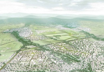
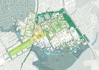
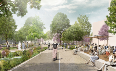
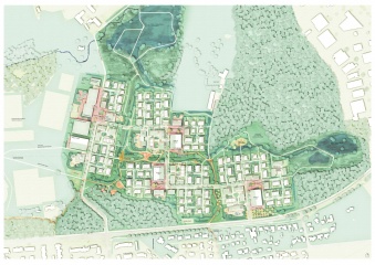
    The concept for the Patrick Henry Village in Heidelberg transforms the former mono-functional military barracks into a multifunctional and identity-creating living environment. The city is being created by the landscape and uses it as a „green zipper", creating a generous connecting space for the inhabitants.

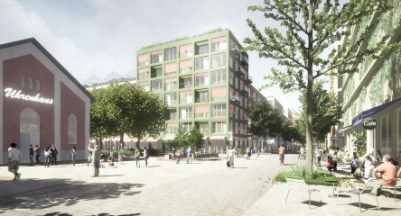
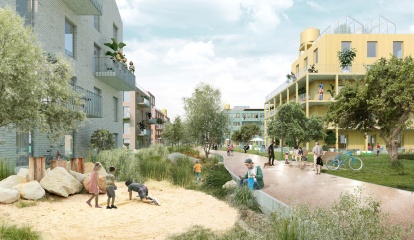
    The design offers the potential to rearrange existing deficits in the monofunctional and structural building and open space structures of the current rows of existing houses from the 1950s, to differentiate them in their design and to program them in many ways. The result is a lively quarter for people and nature with open spaces and buildings made of wood that can be used in a variety of ways. Achieving these goals requires:

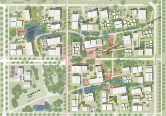
    • A differentiation of the open space framework into rooms with their own characters, functions and possible uses for different age and interest groups.

    • the creation of a diverse landscape to promote biodiversity, improve the microclimate and strengthen local material and water cycles. The two green fingers are designed extensively close to nature, have a large number of biodiversity areas, integrate the tree population and take up the existing topography. The areas are not only becoming creatively powerful elements but also serve to balance residents and residents and as a living space for animals.

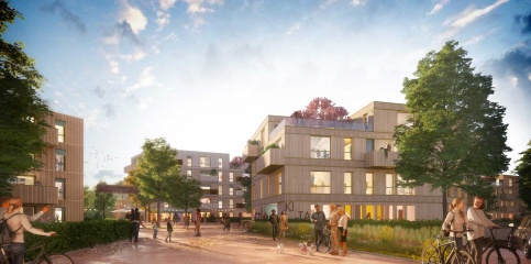
    • A sensitive transformation of the building stock and urban development accentuation of the community fingers through a variety of structural additions in timber construction.

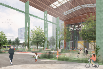
    • the establishment of open ground floors with a high degree of mixed-use along with the community fingers as well as the creation of a wide range of living space. From a daycare centre to a laundromat and neighbourhood shops for residents, there is also space for commercial use of the Fab-Lab and Maker Space, through to factories, exhibitions and events. The available living space is enriched by other, diverse forms of living (small apartments, cluster apartments, shared apartments, family apartments, old people's living, etc.). At the same time, the character of a quiet residential area at the transitions to the Green Fingers is retained.

    • the further development of the existing stock in favour of the grey energy that has already been used.

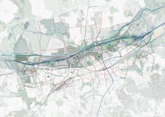
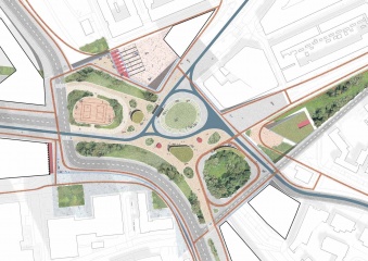
    • the focus on future-oriented mobility, ie "mobility as a service" and active locomotion. Well integrated into an environmental network of trams, shuttle buses and district garages along the parkway, low-car mobility is planned within the district, which is geared towards cyclists and those walking.

    in progress
    2021
  • New Istropolis

    CITYFÖRSTER and KCAP design a new cultural district for Bratislava, Slovakia. Trnavské mýto will house a state-of-the-art concert and congress venue and the area will be transformed into a modern open neighbourhood including a series of green and public areas.

    Immocap, the owner of Istropolis, has presented its vision of New Istropolis, developed in cooperation with the international architectural studios KCAP and CITYFÖRSTER. The project aims to bring Bratislava a world-class multifunctional cultural and social centre with top-level architecture, creating a long deserved cultural landmark for the Slovakian capital.

    The new multifunctional hall enables Istropolis to meet Bratislava's real needs and leverage the potential of Trnavské mýto, and will foster cultural and congress tourism. New Istropolis offers the capacity to host various events simultaneously, such as acoustic, rock, jazz, pop concerts, numerous events and cultural events, and conferences and congresses of all sizes. The hall will be able to hold three different events simultaneously and have a maximum capacity of 3000 seats and 5000 combined seats for sitting and standing. The unique in-the-round seating configuration brings the audience close to the stage, creating a sense of intimacy and connection with the performers.

    Trnavské mýto is a key location in Bratislava in terms of pedestrian movement, traffic, and potential contribution to urban development. The project aims to bring new life to this important part of the city that has been neglected too long. Besides the world-class cultural venue, there will be a park with promenade, fountains, and cycle paths. Public areas will be accessible to visitors throughout the day, while the square will support and develop community activities such as seasonal markets.

    in progress
  • Parkway Heidelberg

    „Think about people first, then about traffic routes. A good city is like a good party. People stay there longer than necessary because they feel good." This quote from Danish urban planner Jan Gehl sums up our planning understanding of the Parkway well.

    The Parkway is a place that is finely networked, that relates building and open space uses in a variety of ways, and that actively supports climate resilience. A green and diverse space that constantly links the opposites of MOBILITY and DISTURBANCE. Due to the valuable and spatially defining existing trees in the Patrick Henry Village as a starting point, the route was designed in such a way that as many woody plants as possible are preserved. Rainwater is stored in swales, infiltration trenches and rain gardens as a valuable resource, benefiting plants and groundwater. The paved areas are reduced to a minimum and designed as light-coloured surfaces.

    The paving material is a newly developed and market-introduced climate stone which absorbs rainfall and can evaporate as much water as a meadow surface (50% instead of 11% to 18% as with conventional paving stones).
    The Parkway fulfils the function of a linear park with a high quality of open space, encounter and stay, serves as an inner and outer distributor for the Patrick Henry Village and provides a safe framework for a broad variety of urban mobility types.

    completed
    2023
  • Marconiplein

    How to raise a dike in an innercity environment?

    Nexus, from the Latin 'nectere', means a "connection or series of connections linking two or more things". Marconiplein is, indeed, at the crossroad of different flows: not only mobility but ecology, water protection, development.

    Our vision is rooted in the understanding of this space as a complex node, where traditionally, absolute priority has been given to transport. Our proposal aims to invert the paradigm of Marconiplein as a space - a sum of several leftover spaces- defined by infrastructures, but rather, addressing high-quality public spaces first, where infrastructural strategy follows. The design of the new square will be led by the principle of unveiling. If in history, infrastructures - considered as a major source of disruption - have been buried, hidden and elevated, technological progress and accurate urban solutions, offer now the opportunity of reconnecting to infrastructures.

    Specific solutions will range from sloping squares, new vertical cross-views, increased number of entrances, fostering the square as a seamless public space, where infrastructure is no more perceived as separated from the city.

    completed
    2021
  • Masterplan Nové Dolíky, Slany

    How can we create a modern suburban environment suitable for pedestrians in a 15-minute neighborhood - a new district with its own urban character that can withstand the ever-increasing pace of changes in human society?

    This is achieved by creating a car-free district that emphasizes pedestrian and cycling transportation, designing compact development that forms both a clearly defined public space and an attractive living environment for future residents.
    The concept of approaching public spaces stems from the fundamental idea of relocating cars to the outer edges of the development. The majority of parking spaces are condensed into three mobility hubs on the corners of the site. The implementation of blue-green infrastructure and the provision of quality public space for the residents of Slaný form a better connection between an agricultural park in the west to the city center in the east. With all amenities within reach and accessible recreational areas, the neighborhood will ensure a healthy and sustainable living environment.

    Part of this design is the establishment of a central green axis, functioning as a retention valley and providing space for trees and biodiversity. It directs the outer landscape and waterflows into the new neighborhood and results in the
    creation of a vibrant blue and green boulevard featuring diverse private and public spaces.

    The urban structure that forms this proposal has been carefully crafted to create compact development with a diversity of typologies and financing models. It is also based on simplicity and elegance for sustainable and prospective construction methods, along with a reliable approach grounded in a connection to nature.

    Idea
    2023
  • Münster-Hiltrup Ost

    BLUE-GREEN NEIGHBOURHOODS

    The design taps into the potential to create a green, climate-adapted and carfree district for Münster Hiltrup that blends harmoniously into the existing landscape and settlement structure. Four compact neighborhoods with a large contact area to the open space will be linked by diverse green corridors in the interior (Green Delta) as well as a close-knit network of cycle paths and footpaths and attractively connected to the outside. Motorized traffic is reduced to a minimum and parking spaces are bundled. Within the neighborhoods, the mobility hubs form everyday hubs. A small-scale, differentiated development structure with ground floor uses at the neighborhood squares, social functions and various, mixed typologies suggest a people-centered scale with a rural character. In conjunction with an innovative climate adaptation concept and high ecological and energy standards, a future-oriented neighborhood development is being created for Hiltrup.

    Rainwater management follows the principle of the sponge city with the aim of minimizing intervention in the natural water balance, achieving near-natural rainfall-runoff behaviour, ensuring sufficient purification of the surface runoff that occurs, preventing flooding in the settlement area and reducing the runoff peaks into the watercourses to a natural level. Implementation is carried out as far as possible using near-natural methods with a small proportion of technical structures. In addition to the purely water management aspects, ecological benefits such as increased biodiversity and heat reduction are achieved. At the same time, blue-green structures are created that allow residents to experience the element of water.

    Idea
    2023
  • MAGNUM-Areal Osnabrück

    The Magnum site's DNA of industrial heritage and landscape succession forms the starting point for the transformation into a climate resilient neighborhood. The unique character of the former steelworks is expressed spatially in the overlapping of the scales of human, machine and nature and of the atmospheres between narrow alleys and wide squares.


    This productive interplay continues to write the history of the Magnum site in constant change. Three subspaces (water courtyards, forest campus, factory cluster) derive from the site, each with its own independent profile, which form synergies with each other and with the neighborhood. The Magnum Mile connects the three subspaces as a lively backbone of the quarter and the adjacent urban spaces to the west and east.


    For the quarter, own systems for the handling of water and soil are developed. They will be used for irrigation, gray water utilization and cooling of the quarter. The goal is to minimize erosion and soil exchange. As much accumulating water as possible is to be collected, filtered and reused. To do this, it will be stored in building-integrated cisterns. Materials collected are reused as much as possible. Existing structures, such as the grove or also hall structures are integrated and the character of the open space and the building structures are developed. The transformation is designed as a gradual, learning and appreciativ process.

    completed
    2023
  • Schamotte Quarter

    From a factory site to a green living quarter!

    The concept for the area of ​​the former fireclay factory in Bonn-Duisdorf transforms the industrial site into a green neighbourhood with a high quality of living. The urban arrangement of the buildings is derived from the noise impact from the south and the location within a larger city block. A four-storey block building with a stagger along the railway line shields the quarter from the noise. Two polygonal, four-storey solitary buildings in the south form the transition to the more loosely arranged buildings in the area. The structurally identical buildings fit into their surroundings by being twisted against each other and creating diverse and exciting spaces through recesses and bends.

    A neighbourhood square is being created that will serve as an identity-forming address and meeting point. An additional green open space stretches to the east, where the opposite entrances to the buildings are located.

    All adjoining municipal and private plots of land in the east and west can be integrated into the urban picture. The existing building, a shelter for the homeless, can be retained and further developed by adding another story and balconies. The green connection in the middle of the quarter will be extended and merged with a green area with a playground. In the west, a solitary structure can provide a clear edge to the neighbourhood square and minimize the noise impact on the inside of the quarter.

    All new buildings are planned as wood hybrid buildings and can be recycled and later returned to the material cycle thanks to their deconstructability. Noise protection, spatial formation, and the quality of living are not dependent on the development of the neighbouring properties, guaranteeing a functioning and green residential area.

    completed
    2022