• Sponge City Hefei: Five landscapes - one park.

    When a park becomes an adventure.

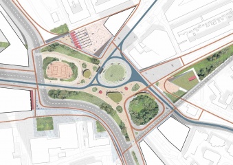
    Building on the master plan for the Sponge City Hefei, we next looked at one of its four large parks. The resulting profile should serve as a sample plan for the remaining zones.

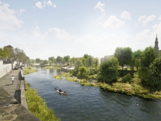
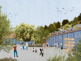
    In the centre of the park, which is divided into five different areas, is the river, which is integrated as a characteristic element of the Sponge City and is of central importance. It acts as a catch basin for precipitation and floods of all kinds and thus contributes to sustainable urban development.

    Depending on the weather and the season, the park looks different and seems to be reinventing itself again and again. If the water coming from both sides of the city causes the river to swell, the park becomes, for example, standing water.

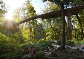
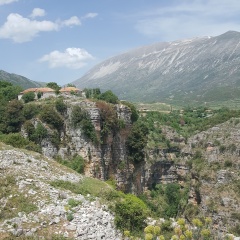
    The many plants and trees that form an entire forest in some areas are a central element of the park itself. In some parts, like the eco shore, the existing vegetation is even integrated and made tangible. In addition to the resulting shade donating places and high natural biodiversity, there is another climate-active aspect: The trees store the water at night, which they release into the air in droplets during the day, thereby helping to lower the temperature.

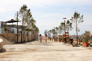
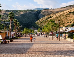
    While on the one hand areas are designed for meetings and events with large sunroofs for a market, for example, there are several leisure options along the spacious boulevard of the urban waterfront. There happen to be boat moorings, an amphitheatre in the water, a variety of cafes, or a specially planned swimming pool. The wetland, however, represents a completely different type of landscape design. In addition to areas with retention basins that function in a similar way, the water slowly seeps away, thereby relieving the sewage system.

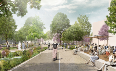
    In order to make the use of a bicycle instead of the car more palatable, a cycle expressway from north to south was planned and cross-paths ensure that the eastern and western residential areas are connected.

    The variety of designed different areas answers every aspect and every question that public space can fulfil.

    For more information, we highly recommend our video about the project on CFTV.

    in progress
  • Sponge City Hefei - Eco Shore

    Various naturally designed areas in the Hefei City Park form the eco-bank. For example, an existing dam wall is expanded to include a so-called eco-berm. Sealing mats, gravel and sediment as well as a layer of wood and larger stones are applied to the existing structure and thereby provide habitats for plants and animals.

    To protect the new habitats, they are only partially accessible to humans. The rich nature with birds, insects, fish and a large variety of grasses, shrubs and trees can be experienced from a respectful distance on guided boardwalks. A unique encounter of plants, animals and people and an exciting retreat in the city.

    An existing wood area in the east will be enriched with more trees and thus become a dense urban forest, which has a positive effect on the microclimate and biodiversity. In addition, a retention soil filter takes on hydrological functions. Rainwater is cleaned here and then fed into the lake.

    A new shallow water zone with bird islands and bird beaches will be reserved for nature. The panorama pier makes it possible for people to experience this part punctually and at the same time opens up the view over the lake. Through the wooden walkways, human activity is concentrated in selected connecting spaces. The shallow banks, overgrown with aquatic plants, give the lake room to expand during heavy rains without flooding the city. The aquatic plants also have a cleaning function and thus improve the water quality of the reservoir.

    under construction
  • Sponge City Hefei - Wetland

    The Wetland Park in the city park of the sponge city of Hefei creates an adventure space from the infrastructure needed to prevent flooding and to clean the drain water. The green-blue complexes will become visible and tangible core elements of the newly emerging city.

    The wet biotope is varied. A variety of visual relationships mediate between the city and the park landscape. Flora and fauna are within reach over the circular footbridges in the middle of the city and, like the various terrace levels, invite you to linger and stroll. Small islands serve as vantage points from which the dynamic water levels can be observed particularly well. In addition, they provide important habitats for various animals and plants and thus promote biodiversity in Hefei.

    A sundeck is planned in the east of the wetland. Urbanity and publicity are lived under the wooden roof. Various levels descend towards the wet biotope, creating a variety of places with different qualities that differ in size, shape and activity.

    Pre-cleaned water from the northern Floodplain Park is further cleaned by plants close to the water before it is fed into the adjacent reservoir. In addition, the wetland biotope improves the city's sponge function: the absorption capacity of the wetland prevents too much water from being discharged directly into the lake, a concept that counteracts potential flooding scenarios. The transition to the lake is fluid while floating islands mediate between wetland and lake.

    under construction
  • Sponge City Hefei - Floodplain park

    The floodplain park in the North of the city park plays a key role in the sponge city of Hefei. The green-blue corridor makes a virtue out of the threat of flooding: Instead of building grey, rigid infrastructure elements hidden under streets and blocks of houses, the park upgrades the required functions and thus creates a socially highly valuable place. It offers space for play, sports and recreation.

    A seating area with a view of the largest retention basin invites you to observe the changing water levels. The different states of the water become an experience by wrapping the park in a constantly changing robe. Also, there are numerous offers: a basketball field, a playground and a skating area, while the adjoining market hall is the starting point for the seating steps along the park.

    As an invitation to stroll, the Scenic Way meanders through the grounds, past meadows and densely planted groves. Numerous flower beds and small pavilions fill the path with small highlights. The dry stream, which carries water when it rains, runs parallel. Direct paths for cyclists and pedestrians connect the opposite parts of the city.

    In addition to the social needs of the city dwellers, the park fulfils another important task: the surface water from the surrounding districts is channelled here and cleaned by hydrophytes in rain gardens. Collected in retention basins, the rainwater can seep away and evaporate. The dry stream diverts any excess water into the wetland. The park is designed for a 50-year flood event.

    under construction
  • Drymades Promenade

    Strolling in vivid nature!

    Located in between the high mountains and the Ionian Sea in the South of Albania, the new 2 km long Drymades promenade wants to emphasize this duality by creating an impression of being immersed in nature and the greenery while having the beach feeling at the same time. By using organic shapes instead of straight lines, we create a green boulevard with different scenarios, points of view and vibes.

    The division in different zones helps on creating diversity and reflects the varieties and characteristics the area presents. The promenade aims to be an experience in itself with more quiet and natural zones on the side and a vivid part, the hotspot area, in the middle. Here you can find an underground bar which also serves as an elevated plaza or also a pier on the water with different functions on it. The project is unified by common elements, materials and concepts along the promenade such as stone walls, sand-coloured concrete paving and cut out stone or furniture in corten steel.

    One of the key elements of the project is the planting in random dispersion. It serves as shading but also helps at shaping the promenade and giving different scenarios and points of view.

    The kiosks, which are always located in the planters, provide the necessary services needed on the promenade. While the fixed bottom part is made of stone walls, the upper part is made from wood and is thought of as a flexible element that can adapt to the different functions and needs. The biggest kiosk serves as a bar and eating place, the smaller ones as newspaper or ice cream shops, and the smallest ones as public toilets and changing rooms. The roof made of corten steel makes the structure a sustainable one. It is slightly elevated from the main structures to allow the air to pass through and cool the structure underneath. It also collects the rainwater and with the proper inclination, brings it to the planter on the back.

    under construction
    2020
  • Dhërmi Waterfront

    The rural south of Albania is gifted with a spectacular coastline, unspoiled natural areas and rich cultural heriatage. Travel is an important driver of the economic development of Albania. However, developments of the past 20 years have been haphazard and do not match the touristic potential of the region. Being part of the Albanian Governments initiative of 'Urban Rebirth', the main objective of this project was the regeneration of the waterfronts of the villages Jalë and Dhërmi. Starting from the outstanding natural beauty of both locations, our aim was to structure and strengthen the coastline and connect it with its surroundings, both physically as well as ideally.

    In Dhermi this included freeing the main promenade from car traffic, providing basic infrastructure such as benches, bins, showers and fountains, but keeping the promenade at a low profile, seeking a continuation with the beach. At the entrance of the promenade an existing structure and a seasonal stream are integrated to form a watersquare, a landmark for the site which will include iconic lettering. A pier serves both for watersports but also as look-out and artificial cliff. The watersquare connects further inland through the 'valley of freshness' and invites for mountaineering and cultural activities.

    completed
    2016
  • Cape Square Durres

    The design of the square strengthens the natural coastline of Albania which can be described as a sequence of capes. Our aim was to turn a necessary element of coastal defence into a public space that strengthened the formerly desolate promenade. The site forms the endpoint of this promenade and is divided into three parts: The park, the square, and the urban cape which acts as a public attraction, free of charge. The Park with the green beds and local trees supports the uniqueness of Durres and is easy to maintain.

    Following the geographical and ecological conditions, 'Cape Square' is seen from far away and invites to climb and play.
    Cape Square has been received extremely well as a real 'European Public Space' playing an important role in the electoral campaign of the incumbent mayor. It has featured in several music videos and countless wedding pictures and has been published and awarded widely. Cape Square is commonly known as 'Sfinksi' (The Sphinx) all over Albania.

    completed
    2015
  • Mühlenleine

    A river in the middle of Hannover's city center holds the potential to be an inviting, green place where city dwellers enjoy spending time. Currently, valuable areas along the Leine's shores between the river and the Cityring are neglected and underused.

    In pre-industrial times, the Leine and its tributaries were among the river systems in northern Germany which had the highest quantity of salmon. During industrialization and the resulting pollution of the water bodies many fish species have disappeared. The reduction of the fish stock is linked for example due to the construction of hydroelectric power plants and dams, and the large-scale river development carried out in the 20th century.

    Numerous projects since the 1970s have restored and improved the water quality and the ecological connectivity. The renaturation of rivers is an important contribution to a resource-efficient and ecological city.

    In the confined spaces of a city, a particularly large number of different demands are placed on water bodies. However, numerous potentials along the Leine remain unused in the inner city. Further, the canalization and urbanization of the stream only allows to a limited extend the return of flora and fauna to the city. Renaturalised rivers in the city can help to cushion the effects of climatic changes. For example, riparian areas can be integrated into flood protection by retaining the water during periods of extreme rainfall. In addition, the design addresses urban planning goals, such as making the river shores more attractive and easily accessible for the citizens.

    Since the Leine is an urban river, it ought to be addressed both in ecological as well as in social terms. Various interventions along the riverbank serve to revitalize and enhance the quality of life. The key part of the project are the renaturation of shore opposite to the "Hohes Ufer", the reduction of the cityring and the fish ladder. In these areas, new habitats for flora and fauna are created along with new places and functions for recreation. The fish ladder close to the Friederiken Bridge, will enable the connectivity and improvement of existing habitats and it will increase the visibility of the Leine in the city as a unique selling point.

    The concept for the renaturation of the Leine was presented on the 29the of September 2022 with the Leinewelle e.V. and Angler Association and published in the Hannoversche Allgemeine Zeitung (HAZ), among others.

    Idea
    2022
  • Blue Eye

    As one of Albania's most important natural sites, the area of ​​the water spring of "Blue Eye" (Albanian: Syri i Kaltër) has been endangered by tourism for years. Our master plan is the attempt to manage "Blue Eye" sustainably and to prepare it for the expected increase in tourism. The integral strategy protects the natural monument while at the same time releasing its full socio-economic potential. This is achieved through various interwoven strategies, such as diversifying the local offering.

    The immediate area of this rare, almost unreal place is a natural monument characterized by sycamore and oak trees. With the ambitions to improve the local infrastructure for sustainable yet more intensive tourism, we developed an integral strategy for spreading the load of visitors during peak season throughout the year by providing yearly services and activities. By introducing new ways of accessing the Blue Eye Monument, we create different scenarios, points of view and vibes (hiking trails, boat trips and a family path). The program is rounded off with a visitor centre, local product shop, camping facilities and a newly developed cultural and social agenda, proposing the possibility of organizing festivals and local markets close but not right next to the Blue Eye. All of that to stimulate the unique character and potential of the area while keeping the nature intact. 

    The result is a natural phenomenon, unique on a global scale and protected for future generations.

    completed
    2020
  • Jale Waterfront

    The rural south of Albania is gifted with a spectacular coastline, unspoiled natural areas, and rich cultural heritage. Travel is an important driver of the economic development of Albania. However, developments of the past 20 years have been haphazard and do not match the touristic potential of the region. Being part of the Albanian Government initiative of 'Urban Rebirth', the main objective of this project was the regeneration of the waterfronts of the villages Jalë and Dhërmi. Starting from the outstanding natural beauty of both locations, our aim was to structure and strengthen the coastline and connect it with its surroundings, both physically as well as ideally.

    In Jale this included freeing the main promenade from car traffic, providing basic infrastructures such as benches, bins, showers and fountains, but keeping the promenade at a low profile, seeking a continuation with the beach. As the beach is very deep and the bay mainly attracts the younger generations, we have been inspired by some of the existing beach-bars that were embedded in rich flowering gardens. Between the beach and the promenade, we have provided a strip of gardens housing 6-7 beach-bars, each with a stable structure to survive the harsh storms in winter. The bars come in three different sizes and allow for all furniture to be stored inside during the cold season.

    Photography: Lucas Hardonk

    under construction
    2016
  • TreeTop Trail Lagodekhi

    Lagodekhi Protected Areas (LPA) in the extreme north-eastern part of Georgia at the southern slopes of the Caucasus and with altitudes from 590 to 3500 m, is one of the world's best-preserved areas with diversity of natural landscapes. The project of developing a TreeTop Trail as a new touristic product is to attract more visitors and, considering the transboundary potential of the LPA, make it one of the most attractive destinations, to be included in future transboundary ecotourism products.

    The concept emphasizes the forest as the protagonist and proposes a minimalistic design, a circular shaped trail that gradually ascends towads the tree canopies. Additional program is added in order to enhance the experience of forest. This includes a watch tower, a dome, a large net, a cave, and multiple platforms.

    in progress
    building permission 2019
  • Parkway Heidelberg

    „Think about people first, then about traffic routes. A good city is like a good party. People stay there longer than necessary because they feel good." This quote from Danish urban planner Jan Gehl sums up our planning understanding of the Parkway well.

    The Parkway is a place that is finely networked, that relates building and open space uses in a variety of ways, and that actively supports climate resilience. A green and diverse space that constantly links the opposites of MOBILITY and DISTURBANCE. Due to the valuable and spatially defining existing trees in the Patrick Henry Village as a starting point, the route was designed in such a way that as many woody plants as possible are preserved. Rainwater is stored in swales, infiltration trenches and rain gardens as a valuable resource, benefiting plants and groundwater. The paved areas are reduced to a minimum and designed as light-coloured surfaces.

    The paving material is a newly developed and market-introduced climate stone which absorbs rainfall and can evaporate as much water as a meadow surface (50% instead of 11% to 18% as with conventional paving stones).
    The Parkway fulfils the function of a linear park with a high quality of open space, encounter and stay, serves as an inner and outer distributor for the Patrick Henry Village and provides a safe framework for a broad variety of urban mobility types.

    completed
    2023
  • Marconiplein

    How to raise a dike in an innercity environment?

    Nexus, from the Latin 'nectere', means a "connection or series of connections linking two or more things". Marconiplein is, indeed, at the crossroad of different flows: not only mobility but ecology, water protection, development.

    Our vision is rooted in the understanding of this space as a complex node, where traditionally, absolute priority has been given to transport. Our proposal aims to invert the paradigm of Marconiplein as a space - a sum of several leftover spaces- defined by infrastructures, but rather, addressing high-quality public spaces first, where infrastructural strategy follows. The design of the new square will be led by the principle of unveiling. If in history, infrastructures - considered as a major source of disruption - have been buried, hidden and elevated, technological progress and accurate urban solutions, offer now the opportunity of reconnecting to infrastructures.

    Specific solutions will range from sloping squares, new vertical cross-views, increased number of entrances, fostering the square as a seamless public space, where infrastructure is no more perceived as separated from the city.

    completed
    2021
  • Nivica - A model for rural development in southern Albania

    In the beginning of May 2018 students and professionals from Albania and the Netherlands went on a trip to Nivica, exploring the village and the region, and drafting first ideas. The team included architects, urban planners, archaeologists, landscape architects and architectural historians. The workshop results built the foundation for the further development of a masterplan for Nivica.

    The goal of this masterplan is to develop a model for a sustainable and prosperous rural economy, with touristic potential within Albania but also on an international scale. As a Living Lab, Nivica allows to experiment with alternative forms of (slow) tourism, small scale investment, renewable energy and local food and waste chains. The masterplan combines the preservation of buildings and structures related to the rich history of the region with a sustainable, diverse expansion of the touristic potential.
    Nivica is meant to be the prototype for Albania's "100 villages" plan, which sets out to fundamentally rethink rural development in the country


    Idea
    2017
  • Mtirala National Park

    Mtirala National Park is considered one of the most important protected areas in the Autonomous Republic of Adjara in Georgia. The name Mtirala (meaning „to cry") is derived from the 4,500 mm of annual rainfall, making it one of the wettest areas of the former Soviet Union.

    The Integrated Masterplan for Mtirala National Park and Korolistavi Village aims to strengthen both wildlife and ecosystem protection as well as local economic development through eco-tourism. CITYFÖRSTER in collaboration with a variety of experts, from business consultancy to mountain bike trail development, developed a masterplan by formulating a 20-year vision for the region, containing 25+ possible interventions promoting and making accessible the "wettest place of Europe" a subtropical European rainforest, as well as a detailed 3-year action plan, eco-tourism and marketing and promotion strategy.

    CITYFÖRSTER organized three workshops with the community of Korolistavi village and three stakeholder's workshops, identifying their goals and vision for Mtirala National Park and Korolistavi village.

    Regarding the Architectural interventions, we were greatly inspired by the extremely peculiar natural situation of the park. Our aim was to design an architecture that doesn't distort but rather amplifies the peculiarities. This was achieved by designing extremely light, compact, and delicate objects.The function of these objects is not to draw attention to themselves but to be used as devices for understanding their natural surroundings.

    completed
    2022