ul class="overview_list " id="projectList">
  • Cross-over

    At the junction between the media harbour area and the economical harbour area, a vibrant district is created, which has the interlacement of space, atmosphere and program as its principle. An encounter place for working, researching, inventing and recovering with a strong connection to the water arises. Two differentiated loops form the basic open-space framework. Central is the entirely experienceable loop of the leisure harbour with the urban city beach, green terraces, rowing club, marina and the "Kesselplatz" - square at the top of the peninsula.

    Future-oriented is also the industrial harbour, which fits like a second cycle in the system, as the industrial world 4.0 changes. Both "ports" get their new head-end structure through the Pier-One. The loops are connected via 6 public spaces, so-called braces, which pave the way for three squares - Kesselplatz, Hafenplatz and city beach - creating customized meeting places for visitors and residents equally. The urban structure is also characterised by the intermeshing of typologies and promotes innovation, creative work and vibrancy. This "striking harbour mixture" with towers, halls and bars forms the identity-creating and highly flexible structure for a vivid and multifunctional quarter.

    Idea
    2019
    40221 Düsseldorf
    Deutschland
  • Space.Perspective.Würzburg.

    The „Space.Perspective.Würzburg." forms the basis for the redesign of the land use plan. The focus is on the concrete space, because only here can competing spatial demands be examined, weighed up and prioritised. Based on a variety of specialist analyses, site explorations and multi-faceted participation formats, a planning instrument case is created from the spatial image, area typology, spatial references, development focuses and synthetic future perspectives. All in all, this results in a strategic spatial image for the entire city, which on the one hand forms a strong framework and on the other hand can react flexibly to changing framework conditions. From this spatial information, very concrete strategic development goals can be derived for the land-use plan, which have already reconciled competition for space and contradictory requirements.

    completed
    2019
    97070 Würzburg
    Deutschland
  • Durres Beach Hotel

    When designing the Durres Beach Hotel in Golem, Albania, CITYFÖRSTER faced the challenge of creating quality within an unpromising context. Golem, a popular beach resort, enjoys a prime location on the sea and is set in a mountainous landscape. However, the village has suffered from uncontrolled development, resulting in a sprawling blanket of buildings. The site for the new hotel is located in the third row from the beach and faces a highway on the other side.

    On the other hand, the site boasts a beautiful forest of mature Mediterranean pine trees and forms an anchor to a potential urban plaza in the south. In order to overcome the challenges, we designed a building rooted in the Modernist tradition, a compact building-block surrounded by greenery. This layout provides the entire building with light, air and space, and secludes the rooms on lower floors from their direct surroundings. An elevated roof garden compensates for the footprint and adds to the overall quality of the new hotel.

    All rooms have highly finished interiors, as well as balconies offering different views – either towards the sea, towards the mountains, or towards the trees. Each balcony is cladded in natural stone from different regions in Albania, which creates a distinct rhythm in the façade. The west façade corresponds to the adjacent buildings, whilst the east façade follows the patterns of trees. The end result is a positive eyecatcher, clearly visible from the highway and the sea.

    completed
    2017
    Shkembi i Kavajes, Rashbull, 2021, Albania
    Golem
    Albania
  • Bergviertel Krampnitz, green I enlived I in motion

    Based on a strong landscape and valuable historical structures, Bergviertel Krampnitz is a forward-looking quarter, creating its own identity as a place to live and work in harmony with the environment. Against the background of a climate crisis and scarcity of resources, it will be sustainably developed and will serve as a centre of life for a broad cross-section of the population. A small-scale and diverse density creates a lively place, is gentle on resources, uses infrastructures efficiently and relies entirely on the mobility of the future - the environmental network.

    Small and large apartments in the same building ensure social diversity, intergenerational living connects young and old and assemblies along with community-oriented housing projects enable self-determined living. The combination of living and working responds to the trend to more strongly combine leisure and work as well as career and family. Strong and diverse open spaces, differently addressing the building plots, bind everything together and enable uses from communal gardening to sports and leisure activities up to generous landscape experiences.

    completed
    2021
    14476 Potsdam
    Deutschland
  • Gardencity 21. Green-urban-connected.

    The fringes of the city hold the promise to live in connection to nature, surrounded by landscape, open space and informal structures. At the same time, areas like these are criticized for their lack of functions, their boredom and their consumption of natural resources. How then – in the spirit of Ebenezer Howard - to create a "green urbanity" which is more diverse, dense, socially mixed and productive while at the same time maintaining the special qualities of the city edge? For the German BBSR, The Federal Institute for Research on Building, Urban Affairs and Spatial Development we developed scenarios on How the Garden City can be translated to the 21st Century?

    A viable model can only ensue when spatial principles and specific qualities are brought and thought together with the processes, structures and stakeholders that shape the city. The planning approach for Garden City 21 therefore draws its topics, concepts and strategies from the context. Four sample areas illustrate how built and unbuilt intertwine, how aspects of a Garden City can be developed not only on the fringes of the city and how it can embrace local competences, programs and structures.
    Scenario-based designs and strategic stories are the starting point, and are used to illustrate the qualities of urban and open spaces, so as to be able to discuss them with stakeholders.

    Link to publication: 'Gartenstadt 21', Bundesinstitut für Bau-, Stadt- und Raumforschung

    completed
    2017
    Am Markt 21, 28195 Bremen, Duitsland
    Bremen
    Germany
  • Dhërmi Waterfront

    The rural south of Albania is gifted with a spectacular coastline, unspoiled natural areas and rich cultural heriatage. Travel is an important driver of the economic development of Albania. However, developments of the past 20 years have been haphazard and do not match the touristic potential of the region. Being part of the Albanian Governments initiative of 'Urban Rebirth', the main objective of this project was the regeneration of the waterfronts of the villages Jalë and Dhërmi. Starting from the outstanding natural beauty of both locations, our aim was to structure and strengthen the coastline and connect it with its surroundings, both physically as well as ideally.

    In Dhermi this included freeing the main promenade from car traffic, providing basic infrastructure such as benches, bins, showers and fountains, but keeping the promenade at a low profile, seeking a continuation with the beach. At the entrance of the promenade an existing structure and a seasonal stream are integrated to form a watersquare, a landmark for the site which will include iconic lettering. A pier serves both for watersports but also as look-out and artificial cliff. The watersquare connects further inland through the 'valley of freshness' and invites for mountaineering and cultural activities.

    completed
    2016
    Rruga Kosova, Vlorë 9400, Albanië
    Himarë
    Albania
  • Blankenburger Süden - Circular City

    The design is based on the concept of a "Circular City", a circular organised neighbourhood, and is guided by the spatial principle "Landschaf(f)tStadt": The landscape creates the city.

    A structural and design focus is on the blue-green infrastructure: a 60-hectare landscape park with garden, forest and water land not only offers various places for leisure, sport and recreation but also provides numerous ecosystem services such as climatisation in urban areas, rainwater management, food production and the strengthening of biodiversity.

    The neighbourhood is divided into four sub-sections, each with its own specific building and open space structure. All buildings open up to green space and offer a variety of affordable housing options. Construction with wood and recycled materials and the creation of blue-green roofs contribute to the neighbourhood's good climate balance. A new type of building, the so-called CYC Hub, acts as a circulation interface. It houses the technical infrastructure of the circular organised neighbourhoods - such as the energy station and the neighbourhood garage with a mobile station as well as socio-cultural and educational facilities such as a kindergarten, youth club, neighbourhood meeting place and neighbourhood management.

    completed
    Berlin
    Germany
  • Closed loop quarters. Between Frankfurt and Taunus

    CITYFÖRSTER has been unanimously selected for the design for the "Stadtteil der Quartiere" (district of the quarters)" in Frankfurt am Main, Germany with a concept that combines urban growth with circularity.

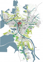
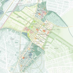
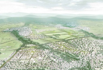
    The central challenge was how to create up to 10,000 apartments and 8,000 new jobs in an agricultural area on the northwest outskirts of Frankfurt, without losing the scenic qualities of this area. At the same time, the design also had to take into account various challenges; for example, like many peripheral metropolitan areas, the region is intersected by infrastructure - of which the six-lane Autobahn A5, which effectively divides the study area in two, has the greatest impact. A situation that is by no means exclusive to Frankfurt or even Germany, but can be found in most cities.

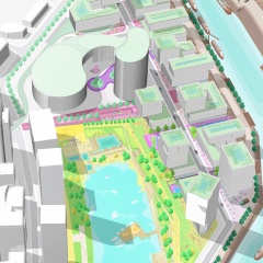
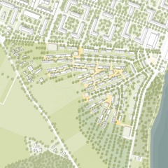
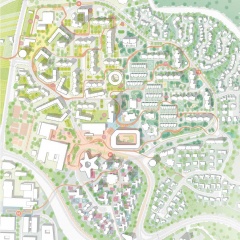
    One of the most remarkable choices was to keep 75 percent of the study area undeveloped, thus preserving the landscape and the connection to the Taunus. The design, which is based on the "Landschaf(f)tStadt" principle, consistently takes the possibilities offered by the landscape and the open space as a starting point.

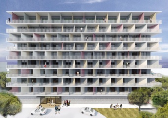
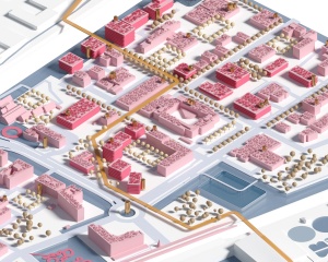
    In order to protect as much of the landscape as possible, the development was kept in compact areas. This means, for example, the abandonment of single-family houses and the planning of mostly apartment complexes of five to six floors, occasionally even higher buildings. The underground and city railways form the backbone of the new districts; the expansion area "Steinbach-Ost" is directly connected to the existing S-Bahn line, and in the districts east of the Autobahn the metro network is being expanded. A number of the neighbourhoods will be car-free.

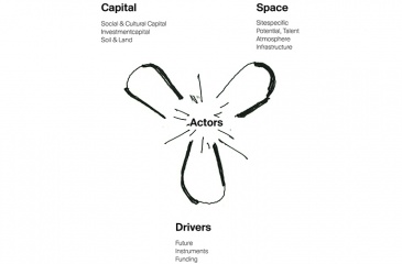
    The aim is to create circularly organized neighbourhoods - neighbourhoods as part of a cycle, in which they make an important contribution to water management, energy, and food supply, that promote environmentally friendly mobility, that regulate the climate and that enhance biodiversity - while naturally offering space for social exchange, providing a home to the community.

    All facts at a glance:

    4 new residential areas
    up to 10,000 apartments
    up to 8,000 new jobs
    5 schools
    20 nurseries
    47 hectares of public green within the neighbourhoods
    425 hectares of study area
    75% of the study area remains undeveloped

    completed
    2021
    Frankfurt am Main
    60439 Frankfurt a.M.
    Germany
  • WHO comes together

    How can you upgrade an existing district, create new living space and create a meeting place at the same time?

    The Tübingen district of Waldhäuser-Ost (WHO) emerged as a satellite town in the 1970s and never really became part of the city. Rather, references to urban development projects from the same period in other cities can be seen: a separation of functions or even a slight reference to the local context characterize urban planning at that time. Similar problems can still be seen today: Inadequate orientation options, unclear and poorly usable footpaths and cycle paths, few or no lively places, little usable open spaces, or even a general island character - isolated from the rest of the city. To counteract this, we have developed three key strategies that create a sustainable WHO.

    1. The barrier-free access belt
    A new hierarchical system of paths works as a connecting band with instead of against the topography. This creates a consistently barrier-free and programmatic network. Additional shortcuts ensure quick routes through the area. The band connects to central locations and stops of the local public transport and thus supports the car-free mobility offers.

    2. Three identity-forming landscapes
    Three landscapes surrounding the WHO hold special qualities. Until now, however, these have not been reflected in the structural and open space structure. Individual features from the landscapes are identified and strategically reflected in the WHO. In addition to vegetation structures and tree species, this also includes materiality and the use of open spaces that create unique places in the WHO and ensure orientation in the area. Enrich productive open spaces, offer room for communal gardening and meeting.

    3. Urban confetti creates density and liveliness
    New sources of inspiration are being strategically placed: a striking building for student accommodation defines the new entrance to the district and enlivens the new district square with a new supply center, school, swimming pool, and public transport stop. The Social-HUB in the geographical center of the district forms an anchor of the social community and spatial orientation. Like urban confetti, different open spaces and building uses are scattered over the area.

    Integrated planning
    The interaction of the three strategies creates a WHO worth living in - designed for people. The access belt leads through three landscapes, through places with different atmospheres and identities, and to different uses. No place in the WHO is like the other. A dense network of meeting places also promotes the community. The synthesis of the three strategies results in new centralities at key locations.

    completed
    Tübingen
    Germany
  • Kenniseiland

    DARE TO INNOVATE!

    As a part of a workshop procedure, Cityförster, together with Openfabric Landscape Architecture and Mijn WaterFabriek Systemen voor duurzam water, proposed an integral strategy for the Business & Science Park of the Kennispark in Enschede that tackles not only the challenges of extreme weather conditions but also the energy transition towards a CO2-free built environment by 2050. The concept is based on the construction of a blue buffer around the location that creates more space for rainwater, recreation and reinforces the identity of the location. Together with a network of smart rain barrels and 'The Hub' arises an inclusive system that celebrates conscious water and energy consumption within a green-blue-minded environment.

    CHALLENGES AROUND WATER MANAGEMENT
    The capacity of our current sewerage system is not designed for extreme downpours. If there is an overload, in a mixed system, the untreated wastewater is dumped into the surface water together with rainwater. That is why it is better to retain the rainwater locally. By temporarily retaining rainwater locally, damage can be limited. The peak of the discharge of rainwater towards the sewer is shifted in this way: the rainwater only flows slowly towards the sewer pipe when it is empty again. Rainwater can be retained by constructing wadis, ditches, above-ground water buffers, green roofs, rainwater ponds, underground storage facilities, water squares, or rainwater use installations. Where soil conditions allow, the rainwater can also be infiltrated directly by softening and greening as much as possible. However, to limit damage during heavy cloudbursts, this must always be combined with other water-retaining facilities, especially in places where infiltration is not possible due to high groundwater levels.

    On average, we use almost 135 liters of drinking water per day. Most of the drinking water is used for showering, flushing the toilet, and washing machines. Drinking is really just a little bit. A family pays an average of almost € 750 for the water supply: 30% of this is for the supply of drinking water, 26% for the sewage charge, and 44% for the purification and water system charges. Instead of disposing of clean rainwater with the sewer, you can also store and use it. Rainwater that falls on roofs is relatively clean. You can use it for the washing machine or the toilet, but also to water the garden. This way, it does not immediately disappear into the sewage system and it also saves drinking water. Furthermore, the consumption of water could be reduced by raised awareness among the citizens and businesses. It is also important to improve the efficiency use by e.g. installing water-saving showers and toilets. Greywater treated in wetland or through filters could also be reused.

    You can find a link to a reader (Dutch) with all the results of the workshop here.

    completed
    7511 AH Enschede
    Niederlande