ul class="overview_list " id="projectList">
  • Mühlenleine

    A river in the middle of Hannover's city center holds the potential to be an inviting, green place where city dwellers enjoy spending time. Currently, valuable areas along the Leine's shores between the river and the Cityring are neglected and underused.

    In pre-industrial times, the Leine and its tributaries were among the river systems in northern Germany which had the highest quantity of salmon. During industrialization and the resulting pollution of the water bodies many fish species have disappeared. The reduction of the fish stock is linked for example due to the construction of hydroelectric power plants and dams, and the large-scale river development carried out in the 20th century.

    Numerous projects since the 1970s have restored and improved the water quality and the ecological connectivity. The renaturation of rivers is an important contribution to a resource-efficient and ecological city.

    In the confined spaces of a city, a particularly large number of different demands are placed on water bodies. However, numerous potentials along the Leine remain unused in the inner city. Further, the canalization and urbanization of the stream only allows to a limited extend the return of flora and fauna to the city. Renaturalised rivers in the city can help to cushion the effects of climatic changes. For example, riparian areas can be integrated into flood protection by retaining the water during periods of extreme rainfall. In addition, the design addresses urban planning goals, such as making the river shores more attractive and easily accessible for the citizens.

    Since the Leine is an urban river, it ought to be addressed both in ecological as well as in social terms. Various interventions along the riverbank serve to revitalize and enhance the quality of life. The key part of the project are the renaturation of shore opposite to the "Hohes Ufer", the reduction of the cityring and the fish ladder. In these areas, new habitats for flora and fauna are created along with new places and functions for recreation. The fish ladder close to the Friederiken Bridge, will enable the connectivity and improvement of existing habitats and it will increase the visibility of the Leine in the city as a unique selling point.

    The concept for the renaturation of the Leine was presented on the 29the of September 2022 with the Leinewelle e.V. and Angler Association and published in the Hannoversche Allgemeine Zeitung (HAZ), among others.

    Idea
    2022
    Hanover
    Germany
  • Racecourse For Future

    How can the area of the former racecourse in the east of Bremen be used as a local recreation area for all citizens of Bremen that, in addition to providing important ecosystem services, continues to allow space for experimentation and the unexpected?

    The racetrack oval becomes a continuous green ring that leads through the different areas. The outer edge is the most precisely formulated in terms of landscape design and the most regulated in terms of operation. It functions as a perceptible spatial framework and as a clear threshold between inside and outside. In addition, two circular paths provide the overarching connectivity here. The openness of the racecourse center is preserved and staged. It remains open for dynamic changes and is a valuable property that has to be negotiated continuously. Sub-areas are characterized in a variety of ways and occupied by different clusters of use. Individual utilization modules profit from the spatial proximity to each other and can form synergies. The central connecting path is supplemented by a network of secondary footpaths and trails. It runs through the different areas of use of the park and enables a direct and intuitive passage through the area.
    The project showcase building at the entrance to the area serves as a hub for networking local actors and sees itself as an open start-up center where new ideas and impulses for the racecourse area are continuously generated.

    The concept preserves and further develops existing landscape and utilization structures. It avoids deconstruction and adds new layers to the site - structurally, functionally, and ecologically.

    Idea
    2022
    Bremen
    Germany
  • Revitalizing Peja's River-Kosovo's Green Corridor

    The entire program consists of roughly 4 components: The City Green Spine, The River Park, Natural Wetlands, and The Multi-purpose Lake.

    City Green Spine aims to provide blue-green solutions for the city of Peja surrounding the Lumbardhi river. The main feature is a green, gradually-stepped riverbank, allowing access to the river and a green space adjacent to the center of Peja.

    The River Park is the section between the city and the newly built wastewater treatment plant. More specifically, it connects with the new urban development area of Peja. The River Park has a twofold aim: (1) manage the river, and (2) provide a green, natural environment for residents and tourists.

    The Natural Wetlands is the section of the river from the wastewater treatment plant to the lake. It is an area that will be more natural than the River Park, which allows the river to move more freely.

    The Development of the Multi-purpose Lake is one of the prestige measures of the program. The current site is degraded due to illegal gravel extraction and pollution. The Multi-purpose Lake will revitalize both socio-economic and ecological values of the site, whilst attracting national and international visitors.

    Connectivity of the urban and rural landscape is essential for accessibility and use of the to-be-developed program components. Measures include hike paths and bike paths from the city centre to the Multi-Purpose Lake, via the River Park and the Natural Wetlands. Lastly, a shuttle service will be developed to ensure easy transit between the city centre and the lake.

    Idea
    2022-2023
    Peja
    Kosovo
  • Buna Delta

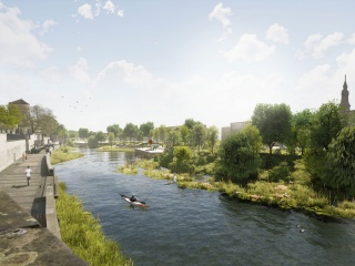
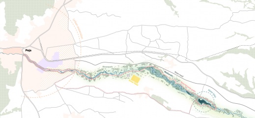
    The Buna river delta, situated in the southeast of Shkodra, Albania, is intricately connected to Lake Shkodra via the Buna, Drin, and Kir rivers, forming a complex hydrological network. This region boasts diverse ecosystems, drawing migratory birds and nature enthusiasts. However, it faces periodic flooding, attributed to factors like heavy rainfall, snowmelt, imbalanced reservoir management, and the mountainous terrain constraining water flow.

    We propose a vision for the future of the Buna Delta, developed in close collaboration with the Municipality of Shkodra, government agencies, international donors and local experts. In this vision, flood protection infrastructure is harmoniously combined with the development of ecotourism and circular economy, as well as the improvement of sustainable mobility between the Adriatic Sea and Shkodra.

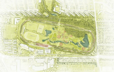
    To achieve flood resilience, a combination of natural and technical solutions is recommended. A combination of natural and technical solutions is recommended to strengthen resilience to flooding. Among these solutions is the organic development of a green river connecting the Buna and Drinasa rivers. This green river acts as a natural strip of land to divert flood water while promoting attractive vegetation. This improves water quality, creates habitats for wildlife and promotes tourism.

    To further protect against flooding, improve biodiversity, develop tourism and promote sustainable land management, measures such as the inclusion of storage areas and buffer zones along the waterfront and a resilient mixed form of agriculture are also proposed.
    By implementing these strategies, the Buna Delta can thrive as a resilient and vibrant ecosystem, providing both environmental and economic benefits for the region.

    Idea
    2023
    Shkoder
    Albania