• Life in Sandbachpark

    SUFFICIENT, DIVERSE, CIRCULAR

    The competition area is the first step in the restructuring of the existing commercial area into a mixed-use residential quarter. Between the cultural axis with a new metro connection in the north and the Sandbach with the future development of a park in the south, the area offers potential for a lively quarter with added value for residents, nature and the neighborhood with open spaces, buildings and services that can be used in a variety of ways. The design is based on a compact urban development that conserves the valuable resource of land and offers space for nature, rainwater management and leisure uses. The unsealed surfaces enable lush vegetation that promotes biodiversity, generates a balanced microclimate and creates atmospherically strong places. To promote the local rainwater balance, rainwater is retained on site, infiltrated, evaporated or stored in cisterns to irrigate plants. A diverse mix of uses including living, working, supply and leisure facilities creates a lively, „complete" district and reduces the need for mobility. A multimodal mobility offer organized in the neighbourhood garage consisting of sharing and e-mo-bility offers, cargo bikes, bicycle trailers, etc. reduces the space required and enables the cost-effective use of current technologies. The sufficiency district approach also reduces individual ownership in favor of shared prosperity, thereby conserving the planet's resources. Flexible (timber)system construc-tion and compact building volumes enable cost-effective construction. The sustainable building materials used, such as wood, clay, straw, etc., are used so that they can be decomposed by type. The necessary energy is generated locally as far as possible - PV on roofs and some facades, as well as geothermal energy, are used.

    Idea
    2024
    40878 Ratingen
    Germany
  • Münster-Hiltrup Ost

    BLUE-GREEN NEIGHBOURHOODS

    The design taps into the potential to create a green, climate-adapted and carfree district for Münster Hiltrup that blends harmoniously into the existing landscape and settlement structure. Four compact neighborhoods with a large contact area to the open space will be linked by diverse green corridors in the interior (Green Delta) as well as a close-knit network of cycle paths and footpaths and attractively connected to the outside. Motorized traffic is reduced to a minimum and parking spaces are bundled. Within the neighborhoods, the mobility hubs form everyday hubs. A small-scale, differentiated development structure with ground floor uses at the neighborhood squares, social functions and various, mixed typologies suggest a people-centered scale with a rural character. In conjunction with an innovative climate adaptation concept and high ecological and energy standards, a future-oriented neighborhood development is being created for Hiltrup.

    Rainwater management follows the principle of the sponge city with the aim of minimizing intervention in the natural water balance, achieving near-natural rainfall-runoff behaviour, ensuring sufficient purification of the surface runoff that occurs, preventing flooding in the settlement area and reducing the runoff peaks into the watercourses to a natural level. Implementation is carried out as far as possible using near-natural methods with a small proportion of technical structures. In addition to the purely water management aspects, ecological benefits such as increased biodiversity and heat reduction are achieved. At the same time, blue-green structures are created that allow residents to experience the element of water.

    Idea
    2023
    Münster
    Germany
  • Biotech Archipelago Mainz

    The Bio-Tech Archipelago is a great opportunity for the city of Mainz to build on its global reputation in the biotechnology sector and at the same time develop a city for everybody. Here, optimal conditions for research and development are combined with housing, leisure facilities and a vibrant landscape for people and nature. The design focuses on favoring cooling wind currents, networking local biotopes and preserving the expansive landscape and thus fullfill the requirements of the sensitive urban location and the associated responsibility for our environment.

    Located as a gateway to the city on Saarstrasse, it communicates structurally, spatially and programmatically between the cultural landscapes of the outskirts of Mainz and the biotech axis. It is both the entrance and keystone of the westward expansion of the city and generates a variety of added urban ecological values and offers for the local environment and the city as a whole. The urban figure opens up to the open landscape in spacious corridors. The building mass is divided into four sub-areas that unite to form a flowing archipelago-like urban landscape around a common open space.

    Idea
    2023
    Mainz
    Germany
  • The Brandenbusch-Eck

    A new entrée to the Villa Hügel

    Based on the design principle "Landschaf(f)Stadt", the new Brandenbusch-Eck is a forward-looking and iden-tity-creating entrance to the Brandenbusch neighbourhood and the Villa Hügel in Essen. A neighbourhood that is being developed sustainably and serves as a centre of life for a broad range of residents. A small-scale and diverse density creates a lively place, uses resources sparingly, utilises infrastructure efficiently and relies on the mobility of the future - eco-mobility.
    Building on the strong scenic framing of the Brandenbusch neighbourhood by the Kruppwald forest and the preservation of valuable biotopes and existing trees, the "green carpet" completes the new entrance to a closed biotope network. This public green space is designed as an inviting gesture to the Hügelpark and the Villa Hügel itself.
    Brandenbusch-Platz, as a publicly effective square and protected new centre, links the new neighbourhood with the existing listed estate and promotes interaction. A new connection is created at the usage level: the social and cultural facilities in the neighbourhood are placed in a new context by the design. The connection between the church and the school is created by the Brandenbusch corner.

    Idea
    2023
    Essen
    Germany
  • Wasserlagen Herne - Masterplan

    The projected population development up to 2035 also shows the trend towards a housing shortage in Herne. Despite this development, vacancies and underused space potential characterize the waterfront area. Due to the strong commercial and industrial character of the area and the dominance of large infrastructures, the existing residential areas are exposed to high levels of noise pollution. A lack of open spaces and cultural facilities, difficult permeability for pedestrians and cyclists, as well as major weaknesses in local mobility, which is too strongly oriented towards private motorized transport, exacerbate the problem of isolated residential areas and the associated social imbalance in the area. Underused areas, vacancies and wastelands lack a coherent development perspective. Added to this are the deficient conditions in the housing offer and the external influences of the climate, energy and health crises with their very own challenges. This downward spiral must be counteracted by integrated and future-oriented planning for the entire area of the water locations. The planning objectives therefore focus on a diversified range of housing with a high degree of social diversity and programmatic mix; on the integrated development of high-quality commercial areas and the harmonization of housing, work, industry, open space, leisure and transport. A multimodal, transport connection and the structural, open-space networking of the entire area are the key factors. The planning objectives therefore focus on a diversified range of housing with a high degree of social diversity and programmatic mix; on the integrated development of high-quality commercial areas and the harmonization of housing, work, industry, open space, leisure and transport. Multimodal transport connections and the structural, open space networking of the entire area play a key role. Overarching climate goals come into focus and are linked to ongoing processes such as the coal phase-out or flood and heat protection through the Emscher conversion and sponge city principles.

    completed
    2022
    Herne
    Germany
  • Theoretikum Halle - Der adaptive Campus

    Closing the gap between the university hospital in the north and the biotechnology campus in the south, the THEORETIKUM complements the science and business location in the north-west of the city of Halle an der Saale. The development site is simultaneously integrated into the urban space, functionally connected to the research and teaching facilities and integrated into the landscape. The proposed concept sees itself as a gradually growing, learning and responsive campus that integrates the existing and takes a holistic view of the new. With innovative research and technology clusters, attractive teaching and learning facilities as well as new service and communication areas, functions are bundled, synergy effects are created and potential for supra-regional impact is generated. As an adaptive campus, the THEORETIKUM is more than its individual clusters.


    The urban structure is formed by the campus loop as an address-giving backbone, a functional overlay of the clusters, building plots with adaptive development options and the integration of landscape qualities. Buildings with independent appearances (old - new, small - large, flat - high, square - rectangular) fit together playfully and, along with the uniform open space design, form a versatile, coherent overall picture. The slightly twisted structures create interesting and surprising room sequences and integrate existing elements (buildings, trees, paths) during the various expansion stages. Three existing high-rise buildings will be retained in the long term as a highly visible ensemble and will be integrated into the campus development.
    The northern entrée forms a counterpart to the UKH and is visually and functionally linked by the redesign of the junction. The pandemic center as the first building block is set back slightly and, together with the campus kiosk, conveys the leap in scale from the existing high-rise building to the loose residential development in the surrounding area. The southern entrance is designed at the mobility hub with an active ground floor. The technology and research centers will be realized as compact building blocks with inner courtyards or atriums and base floors. The active heart is formed by the service and communication center at the intersection of the urban north-south and green east-west connection.

    Idea
    2023
    Halle an der Saale
    Germany
  • Bremen Könecke Areal

    Hemelingen on the move - A new urban neighborhood Könecke-Areal

    The revitalization and reintegration of inner-city industrial areas is one of the most important planning tasks of the day. These areas are usually excellently developed in terms of infrastructure, which supports sustainable development, and can save a lot of gray energy. Complex ownership, emission sources and soil contamination are challenges that require innovative, robust and flexible urban planning concepts. The design takes advantage of the unique opportunity to free the area from its infrastructural island location in order to reconnect the districts of Hastedt, Seebaldsbrück and Hemelingen by building an urban bridge. Together with the southern (former) Coca-Cola site, which was part of a former urban design process, it forms the new center of Hemelingen.
    The vacated areas will provide what the district needs now and, in the future, - that is an affordable and diverse housing mix, adaptable spaces for working, learning, leisure and culture, but above all it is urgently needed public green space. The new neighborhood park forms the green heart of the entire district and creates a strong address to the future premium bike route that will connect the neighborhood with the center of Bremen.

    Idea
    2023
    Bremen
  • Klimaquartier Würselen

    The Klimaquartier Würselen is characterized by strong open space references and clearly defined urban spaces. It mediates between the new and existing settlement bodies, the various neighborhoods and the open landscape in the east. In order to meet the current climatic changes and the scarcity of resources, the neighborhood will be developed in a space- and material-saving manner using timber construction; water and other resources will be used locally and treated on site.

    The new neighborhood landscape complements the existing open block perimeter while forming defined neighborhoods with intimate courtyards that combine village courtyard structures with play streets. The small-scale buildings surround the Green Center, which forms the heart of the neighborhood and functions as a meeting space for the surrounding neighborhoods.

    All buildings are based on the same construction grid, which corresponds to the deep garage grid of 5m. The bulkhead construction method, optimized for timber construction, forms the basis for the feasibility of the various building typologies. At the same time, repetitive building elements and construction principles ensure efficient planning and minimized construction times. The efficient basic structure allows for a variety of floor plan types - from one-room apartments to row houses to group apartments.

    Idea
    2022
    Würselen-Broichweiden
  • Ludwigsfeld München

    Like a coat, the development wraps itself around the greened-out Ludwigsfeld estate. It does this conceivably loosely and discreetly over open spaces. The dissolution of grains and densities of use is small-scale in relation to the existing buildings and protects them from noise at the edges.

    The concept proposes four different urban building blocks to complement the Ludwigsfeld settlement: green residential courtyards, active neighborhood houses, a cautious addition to the existing buildings, and flexible neighborhood garages.
    Through compact and green residential courtyards with a diverse appearance, a variance in the number of stories and vertical greening, the targeted density is achieved with high residential and open space quality. In relation to the existing buildings, the residential courtyards dissolve into an open development, which also adapts in terms of the number of stories and mediates via community gardens.
    Four neighborhood houses at a central location in the neighborhood link the living with base areas for supply, social facilities and community uses. As project building sites, special forms of housing can be implemented here in alternative development models. Through a striking design and the active ground floor areas, they are crystallization points in the public space.

    The design supports the goal of a sustainable and CO2-neutral neighborhood development. The infrastructures required for the planned energy concept are integrated into the urban design and areas for energy generation are demonstrated accordingly.

    Idea
    2023
    Ludwigsfeld, München
  • Railway District

    The starting point of the urban development concept is the creation of two strong open space connections that act as a green bracket, embedding the new quarter in the urban context in a variety of ways and interweaving it with this context. The green bracket links the very different and previously separate urban open spaces of Gleisharfe and Hauptfriedhof. The two open space sequences structure the hitherto unorganized urban space and give the neighborhood development a clear contour.

    The adjacent greenery flows into the neighborhood and picks up on the existing space-creating structures such as groups of trees and fallow land to interweave them with the neighborhood spaces. This creates a lively place with its own identity in a central location. The guiding ideas of BAHNSTADT are consistently developed further. In the midst of the green brackets, a compact and densely mixed urban quarter is created, which is divided into sub-segments by three axes across the green spaces. They create direct path relationships and clear orientation in the urban space.

    completed
    2022
    Braunschweig
  • Parkway Heidelberg

    „Think about people first, then about traffic routes. A good city is like a good party. People stay there longer than necessary because they feel good." This quote from Danish urban planner Jan Gehl sums up our planning understanding of the Parkway well.

    The Parkway is a place that is finely networked, that relates building and open space uses in a variety of ways, and that actively supports climate resilience. A green and diverse space that constantly links the opposites of MOBILITY and DISTURBANCE. Due to the valuable and spatially defining existing trees in the Patrick Henry Village as a starting point, the route was designed in such a way that as many woody plants as possible are preserved. Rainwater is stored in swales, infiltration trenches and rain gardens as a valuable resource, benefiting plants and groundwater. The paved areas are reduced to a minimum and designed as light-coloured surfaces.

    The paving material is a newly developed and market-introduced climate stone which absorbs rainfall and can evaporate as much water as a meadow surface (50% instead of 11% to 18% as with conventional paving stones).
    The Parkway fulfils the function of a linear park with a high quality of open space, encounter and stay, serves as an inner and outer distributor for the Patrick Henry Village and provides a safe framework for a broad variety of urban mobility types.

    completed
    2023
    Heidelberg
  • MAGNUM-Areal Osnabrück

    The Magnum site's DNA of industrial heritage and landscape succession forms the starting point for the transformation into a climate resilient neighborhood. The unique character of the former steelworks is expressed spatially in the overlapping of the scales of human, machine and nature and of the atmospheres between narrow alleys and wide squares.


    This productive interplay continues to write the history of the Magnum site in constant change. Three subspaces (water courtyards, forest campus, factory cluster) derive from the site, each with its own independent profile, which form synergies with each other and with the neighborhood. The Magnum Mile connects the three subspaces as a lively backbone of the quarter and the adjacent urban spaces to the west and east.


    For the quarter, own systems for the handling of water and soil are developed. They will be used for irrigation, gray water utilization and cooling of the quarter. The goal is to minimize erosion and soil exchange. As much accumulating water as possible is to be collected, filtered and reused. To do this, it will be stored in building-integrated cisterns. Materials collected are reused as much as possible. Existing structures, such as the grove or also hall structures are integrated and the character of the open space and the building structures are developed. The transformation is designed as a gradual, learning and appreciativ process.

    completed
    2023
    Osnabrück
  • Köpenicker Gleislandschaften

    The development of the former freight station Köpenick offers a unique opportunity to create urgently needed living space and jobs in a central, well-connected location in the immediate proximity of diverse natural landscapes. The major challenge here is dealing with the noise emitted by the railroad tracks, the industrial activity, but also the new eastern ring road.

    An open space ribbon links the area with its surroundings, takes over important climatic functions and crosses the neighborhood with public open space uses. An elementary part of the band is the undeveloped area in the north-east along the tracks, which leads the forest into the quarter and is a local recreation area and important retreat for flora and fauna. Noise protection typologies oppose the noise sources in the area and form an urban noise protection. This allows for a quiet neighborhood core with quality housing, quiet open spaces, and working environments. Uses evolve from the surroundings and respond to the differentiated context. This creates new synergies and promotes a functioning neighborhood.

    The „Köpenicker Gleislandschaften" transform the former freight station into a diverse, mixed and sustainable urban quarter, creating a strong edge at exposed locations and high-quality living in the inner neighborhood.

    Idea
    2022-ol23
    Köpenick, Berlin
  • Ibbenbüren Tor West

    As the entrance to INOVA Park, „Tor West" productively brings together history and the future, offers elastic development possibilities and is supported by a robust open space structure. The central museum square offers a lively place to linger for arriving visitors, museum guests, users of the daycare center located there, and adjacent commercial workers.

    Three design guiding themes form the basis of the development concept:
    1. creation of a strong open space structure. This links the area in many cases via a robust and high-quality design with the northern Gleispark, the Osnabrücker Straße and the open cultural landscape in the south .
    2. integration of historic preservation and new buildings. With the preservation of monuments and integration of these into a clearly structured new building structure, a variety of spatial and functional relationships are created.
    3. the clearly structured commercial building areas allow the settlement of many small-scale to a few large-scale uses due to the efficient developments (delivery traffic, MIV, bicycle and pedestrian traffic) and the flexible building orientations and depths. Public generating functions are located at the entrance square and the museum.


    The open space performs important climate functions and, with its permeable structure, has good connectivity to the surrounding landscape. North-south connections support ground-level cold air flow for effective summer night cooling. A tall tree population binds fine dust, improves air quality, and provides a high level of comfort in the outdoor space.

    Idea
    2022
    Ibbenbüren
    Germany
  • Climate Quarter Wolfsburg Fuhrenkamp

    The neighborhood at Fuhrenkamp takes on the responsibility of a climate-friendly settlement. The compact development minimizes the degree of sealing and creates generous green spaces with dense tree populations. These air-condition the neighborhood and increase biodiversity. Stormwater management functions according to a sponge city and cascade principles, in which rainwater is retained and temporarily stored, evaporates and infiltrates or is discharged into local ditches. Renewable energy is generated locally.

    The use of durable materials, building with used and recycled materials, and a wood construction method contribute to climate protection. Promoting and enabling a change in mobility behavior achieves a low-car neighborhood. The climate quarter creates a social mix by offering diverse, also new forms of housing as well as friendly street spaces for play and circulation, diverse open spaces and neighborhood centers for all generations.

    The Fuhrenkamp neighborhood is being developed in phases, beginning in the south and growing out of the city. The development in individual steps makes it possible to learn from what already exists and to make appropriate adjustments to meet changing needs. The edges of the individual neighborhoods in the area react in a differentiated manner to their context: the neighborhoods leave sufficient distance to the section of forest to the west. At the same time, the biotope network is strengthened and expanded in a vertical direction between the existing structures and the new neighborhoods to the east. The new district is holistically interconnected through a framework of neighborhood centers.

    Idea
    2022
    Wolfsburg
  • Racecourse For Future

    How can the area of the former racecourse in the east of Bremen be used as a local recreation area for all citizens of Bremen that, in addition to providing important ecosystem services, continues to allow space for experimentation and the unexpected?

    The racetrack oval becomes a continuous green ring that leads through the different areas. The outer edge is the most precisely formulated in terms of landscape design and the most regulated in terms of operation. It functions as a perceptible spatial framework and as a clear threshold between inside and outside. In addition, two circular paths provide the overarching connectivity here. The openness of the racecourse center is preserved and staged. It remains open for dynamic changes and is a valuable property that has to be negotiated continuously. Sub-areas are characterized in a variety of ways and occupied by different clusters of use. Individual utilization modules profit from the spatial proximity to each other and can form synergies. The central connecting path is supplemented by a network of secondary footpaths and trails. It runs through the different areas of use of the park and enables a direct and intuitive passage through the area.
    The project showcase building at the entrance to the area serves as a hub for networking local actors and sees itself as an open start-up center where new ideas and impulses for the racecourse area are continuously generated.

    The concept preserves and further develops existing landscape and utilization structures. It avoids deconstruction and adds new layers to the site - structurally, functionally, and ecologically.

    Idea
    2022
    Bremen
    Germany
  • Campus Delta Heilbronn

    In order to bring people, ideas, opinions and uses together in a diverse way and at the same time to make an important contribution to adapting to climate change, the CampusDelta is being created as a learning landscape and a place of knowledge on the banks of the Neckar.

    The CampusDelta creates an urban structural transition between commercial and residential areas through compact building structures with clear building edges to the northern street space and an open, smaller-grained building structure to the southern riverside park. The new central campus mile connects the northern education campus, the Neckarbogen and the access road heading north to the Wohlgelegen innovation park. This urban axis functions as a superordinate networker, as a central movement and orientation zone for the campus and creates a clear address side for the buildings. Along the mile are diverse recreation zones, small and large squares, as well as the important primary functions of the campus. The characterful buildings of the campus are compact, differentiated in structure, hybrid in use, and feature striking roofscapes and green facades. Small-scale organized first floor zones and open foyers give the architectures a human scale and support the diversity of uses inside and out.

    Shaped from the landscape, the campus minimizes sealed surfaces, maximizes open space and thus biodiversity as well as near-natural water management, and relies on renewable building materials, climate-neutral energy supply and sustainable local mobility.

    Idea
    2022
    Heilbronn
    Germany
  • New Kiellinie

    The Kielline connects the southern center of Kiel along the Förde with the northern district of Wik. It stages the impressive scenery of the Kieler Förde and is - especially during Kiel Week - a hotspot for events and tourism.

    The Kiellinie is an important place of Kiel's identity as a city by the sea. In order to strengthen this identity, the new Kiellinie represents a connecting open space on all scales for Kiel. It combines city, landscape and water to form an ecosystem. The result increases the well-being of Kiel's people as well as the biodiversity of the flora and fauna of the Förde coast.

    The Kiellinie is divided into three sections with different atmosphere, use and design. In the north, the „Förderküstenbiotop" renaturalizes the shore edge and offers local recreation areas for residents from the neighborhoods. The middle section stages a panoramic view of the water and the opposite neighborhoods. The pulsating mile represents the tourist center and lively heart of the Kiellinie. The different sections are held together by common design elements and form the identity of the Kiellinie. The defining element is the new stone of the shore edge, which continuously stages the topographical edge between water and land. The Kiellinie adapts to the different spatial and programmatic requirements and yet forms a recognizable identity in Kiel's urban space.

    completed
    2022
    Kiel
    Germany
  • Klima-Mosaik

    For the neighbourhood, a robust and at the same time adaptable concept is proposed, developed from the landscape and the context. Through a variety of qualified open spaces and a communal centre, neighbourhood, density and sufficiency can be thought differently.

    Approximately 250 residential units of varying design will be created in the neighbourhood. In order to create affordable housing, the focus is on multi-storey housing. With the building types row, point, angle and double, there are four variants of multi-storey housing in the neighbourhood. The diverse housing offer is complemented by 38 terraced houses. The neighbourhood cluster in the centre lends itself to cooperative development with complementary uses.

    The natural appearance of the neighbourhood is paramount. The use of sustainable materials offers ecological and technical advantages at the same time. Apart from the design specifications for typologies and spatial edges, the variance in facade and colour design, as well as in the open space elements of the individual neighbourhood clusters, ensures individuality and orientation. Design elements from the context create a sense of belonging to the surroundings, while communal spaces offer space for self-realisation.

    The "Klima-Mosaik" is characterised by strong open space references, diverse forms of housing and an active, communal neighbourhood centre (including a meeting place, co-working, special forms of housing). In addition, the neighbourhood hub bundles mobility services and other uses (e.g. workshop, parcel station, youth meeting place).

    completed
    2022
    Fehmarn
    Germany
  • Humboldtblock

    The Humboldt Block combines existing and new buildings to create a new productive quarter with a character know for Berlin, connects on many levels with its surrounding and can respond flexible on future challenges. The urban design aims to connect the area wit its surrounding - on one side the Humboldthain as an important open space, on the other side with the adjacent areas and institutions of the technology park.

    The structural setting completes the perimeter development of the building block along Gustav-Meyer-Allee. Existing and new buildings merge to form a quarter with a strong character, creating an outside view typical for the location. The part on Gustav-Meyer-Allee with its public first floor areas form the showcase, representing the new quarter. In the center of the Humboldt Block, a sequence of squares is created to connect the entrances of the new and old buildings. Those buildings face each other and form a common public space.

    The development is divided into nine north-south oriented strips of buildings, some of which are grouped together by internal courtyards. The main internal development for delivery traffic divides the resulting building strips in an east-west direction. The permeable building structure opens generously to the Humboldthain and links the quarter with its surroundings. The main thoroughfare is aligned with the two existing crosswalks of the block.

    completed
    2022
    Berlin
    Germany
  • Mühlenleine

    A river in the middle of Hannover's city center holds the potential to be an inviting, green place where city dwellers enjoy spending time. Currently, valuable areas along the Leine's shores between the river and the Cityring are neglected and underused.

    In pre-industrial times, the Leine and its tributaries were among the river systems in northern Germany which had the highest quantity of salmon. During industrialization and the resulting pollution of the water bodies many fish species have disappeared. The reduction of the fish stock is linked for example due to the construction of hydroelectric power plants and dams, and the large-scale river development carried out in the 20th century.

    Numerous projects since the 1970s have restored and improved the water quality and the ecological connectivity. The renaturation of rivers is an important contribution to a resource-efficient and ecological city.

    In the confined spaces of a city, a particularly large number of different demands are placed on water bodies. However, numerous potentials along the Leine remain unused in the inner city. Further, the canalization and urbanization of the stream only allows to a limited extend the return of flora and fauna to the city. Renaturalised rivers in the city can help to cushion the effects of climatic changes. For example, riparian areas can be integrated into flood protection by retaining the water during periods of extreme rainfall. In addition, the design addresses urban planning goals, such as making the river shores more attractive and easily accessible for the citizens.

    Since the Leine is an urban river, it ought to be addressed both in ecological as well as in social terms. Various interventions along the riverbank serve to revitalize and enhance the quality of life. The key part of the project are the renaturation of shore opposite to the "Hohes Ufer", the reduction of the cityring and the fish ladder. In these areas, new habitats for flora and fauna are created along with new places and functions for recreation. The fish ladder close to the Friederiken Bridge, will enable the connectivity and improvement of existing habitats and it will increase the visibility of the Leine in the city as a unique selling point.

    The concept for the renaturation of the Leine was presented on the 29the of September 2022 with the Leinewelle e.V. and Angler Association and published in the Hannoversche Allgemeine Zeitung (HAZ), among others.

    Idea
    2022
    Hanover
    Germany
  • Max-Becker-Areal

    The 17,3 ha site is currently isolated from the urban space and polluted with emissions. The environment is characterized by deficits in the open space and local supply with green spaces and represents a structural and programmatic caesura in the otherwise small-scale district structure of Ehrenfeld.

    With the „Best-Of Ehrenfeld" an open quarter with a strong character is created, which combines a high urban density with open, diversely networked and richly programmed open spaces. It is a Cologne Veedel (Kölsch for „quarter") in the best sense of the word: living, working, culture and education are fused in small spaces and linked with each other over short distances. The mix of uses is derived from the urban planning concept at the construction site level. The new district is green, culturally anchored and creatively attractive.

    The urban development forms a structural and programmatic bridge between the districts of Ehrenfeld, Müngersdorf and Braunsfeld. Urban density and diversity meet a green network with a wide range of offers and possible uses.

    in progress
    2023
    Ehrenfeld, Cologne
    Germany
  • Framework plan Hafenband+

    maritime. green. communal.

    The framework plan for the Hafen-Ost (harbour east) quarter in Flensburg forms the basis for the development and transformation of Hafen-Ost into a climate-friendly and sufficiency-oriented city neighbourhood with mixed uses and a wide range of open spaces.

    Based on three possible development scenarios, a cooperative development process was carried out to create the framework plan involving the city, politics, stakeholders and the population. The result is the synthesis scenario "Hafenband + maritime. green. communal.", which creates the basis for the framework plan.

    In addition to the framework plan with an urban and landscape planning concept, a development and utilization concept and an integrated mobility concept, the focus under the topic "How will less be enough?" is on the development of a sufficiency quarter for approx. 1000 units and up to 2,000 AP in an inner-city location.

    in progress
    2021
    Flensburg
    Germany
  • Schamotte Quarter

    From a factory site to a green living quarter!

    The concept for the area of ​​the former fireclay factory in Bonn-Duisdorf transforms the industrial site into a green neighbourhood with a high quality of living. The urban arrangement of the buildings is derived from the noise impact from the south and the location within a larger city block. A four-storey block building with a stagger along the railway line shields the quarter from the noise. Two polygonal, four-storey solitary buildings in the south form the transition to the more loosely arranged buildings in the area. The structurally identical buildings fit into their surroundings by being twisted against each other and creating diverse and exciting spaces through recesses and bends.

    A neighbourhood square is being created that will serve as an identity-forming address and meeting point. An additional green open space stretches to the east, where the opposite entrances to the buildings are located.

    All adjoining municipal and private plots of land in the east and west can be integrated into the urban picture. The existing building, a shelter for the homeless, can be retained and further developed by adding another story and balconies. The green connection in the middle of the quarter will be extended and merged with a green area with a playground. In the west, a solitary structure can provide a clear edge to the neighbourhood square and minimize the noise impact on the inside of the quarter.

    All new buildings are planned as wood hybrid buildings and can be recycled and later returned to the material cycle thanks to their deconstructability. Noise protection, spatial formation, and the quality of living are not dependent on the development of the neighbouring properties, guaranteeing a functioning and green residential area.

    completed
    2022
    Bonn Duisdorf
    Germany
  • Framework plan federal district of Bonn

    In recent years, the Bundesviertel in Bonn has transformed into a successful business location and headquarters of the United Nations. Today, the district in the former federal capital faces new challenges to remain and become attractive as a location for companies, politics, international institutions and congresses and at the same time as a 'piece of the city'. The aim of the framework plan is therefore to show an integrated approach for future development.

    One of the main goals of the structural concept is to preserve and strengthen the identity-creating areas and to develop the inner potential areas structurally and openly in a sustainable manner. With the increase from currently around 4,000 to around 15,957 inhabitants, new needs arise in terms of supply and socio-cultural infrastructure.

    The Bundesviertel of the future is urban mixed, offers affordable and attractive living and working space, is characterized by social and cultural, sports, leisure and supply offers as well as high-quality open spaces. Through more and a variety of living spaces, commuters become residents. As a sustainable location, the Bundesviertel is changing from a simple office location to a work landscape ('work-life blending'). A crisis-proof and innovation-promoting mix of industries offer employees an attractive working environment.

    The concept is rounded off by a high-performance transport infrastructure that guarantees quick accessibility and good internal networking: An important role model for the traffic turnaround: cycle paths and footpaths are being greatly expanded and public transport is being strengthened.

    completed
    2022
    53113 Bonn
    Deutschland
  • Time for Lausitz

    1 room | 2 engines | 3 fields

    With the cessation of coal mining and power generation, the region of the Lausitz is deprived of one of its central economic foundations. Many employees will lose their jobs as a result of the necessary climate and structural policy decisions. At the same time, the region is confronted with the ecological consequential damage caused by years of resource depletion.

    The crisis-ridden development shows that a sustainable economic, social and ecological development in the Lausitz can no longer be based on linear systems, but that a circular economy must be built up more and more and on various levels and standards. It is time to promote material cycles, energy cycles, the hybridization of infrastructure, the networking of sectors and value chains, to establish synergies and to generate meaning.

    The key to sustainable development in the Lausitz is a careful approach that is differentiated in terms of time and space. There are a handful of clearly identifiable development drivers that can add value to the region in the short- and medium-term. They form the drivers of regional development, so to speak, and also network the Lausitz nationwide. Promoting them in a targeted manner should be the first focus of the investment.

    With the conversion of the Lausitz into a model region for organic farming, sustainable forestry and resource-conserving timber management, it can not only open up new sources of income for the primary sector but also significantly increase the attractiveness of the region as a place to live, as a location and as a holiday resort/destination. The structural funding promised for the phase-out of coal should therefore also benefit the primary sector and thus strengthen sustainable value chains.

    completed
    2021
    Territory of Lusatia (Lausitz), southern Brandenburg and eastern Saxony
    Germany
  • Holtenau-Ost

    New urban coastal landscapes

    With Holtenau-East, a new urban coastal landscape is being created on a former military site on the banks of the Kiel Fjord, which interweaves previously separate settlement structures and natural habitats. Holtenau East is defined by two impressive local scenes. On the one hand the Kiel Fjord with its maritime waterfront, on the other hand, the Endmoränen forest with its distinctive topography. They not only create the stage for the new development but are protagonists by representing the climatic, ecological and cultural context. The design further develops these two elements in terms of landscape and urban development and combines their spatial and atmospheric qualities to create a new urban coastal landscape. The result is three urban landscapes with a strong character.

    Together they form a closely networked and circular district landscape developed from the site. The three quarters provide strong, site-specific answers to future living, work and leisure needs. They differ in their use of water through adapted and integrated flood and sponge city concepts that strengthen the local ecosystems. Diverse structural and open space uses close to the water ensure a high quality of living. At the same time, they improve the range of jobs, supply, cultural and leisure offers for Holtenau and the surrounding communities.

    The rainwater is collected decentrally on green roofs and retention areas and feeds a central wetland, which reduces the rainwater load on the drainage system during peaks of precipitation. The wetland saves supply costs and complements the public space with atmospheric elements. It also offers a habitat for birds and butterflies, offers potential for nature-educational offers and protects the area from flooding.

    Idea
    2021
    Kiel-Holtenau
    Germany
  • Bochum Gerthe-West

    Three neighbourhoods for a green network.

    The focus of the spatial image for the inner-city development Bochum Gerthe-West is the connection and interweaving of the existing green spaces. As a starting point for the design, they create a new ecological corridor and open space network. Furthermore, the connections between existing centralities and free spaces are strengthened and supplemented with new sources of inspiration, such as new daycare centres and mobility hubs. Strategically placed, they form bridges between the building structures and natural areas and invite you into the green.

    The design suggests a coherent and lively green sweep that can be experienced and used by residents and residents through small-scale path connections and other open space functions.

    The rich stock of shrubs and trees creates distinctive rooms and atmospheres. Building structures are specifically inserted here. This creates a compact residential area in the northern part that fits into the built urban context. The focus here is on diverse neighbourhood-related open spaces that offer room for communal uses. In the northeast, the green urban landscape is supplemented by four rows of block edge and row house typologies. They define clear settlement edges between the residential area and the landscape and still have strong visual references to the vastness of the adjacent fields. The Green Ring runs between the neighbourhoods, taking up the striking trees and networking the area for non-motorized traffic.

    New typologies are set along with the dense forest structure in the heart of the project area. In the so-called wilderness quarter, residents can experience nature. Open, small-grained and carefree play with the trees, the new buildings create an urban wilderness.

    Key figures
    Area of ​​new development: 19,302 m² (21,769 m² *)
    Gross floor area new development: 60,771m² (68,173m² *)
    Sealed areas total: 59,286 m²
    Total unsealed areas: 63,980 m²
    Approximate number of residential units: 560 (625 *)
    Number of parking spaces in district garages: 557 (668m² *)
    *including optional surfaces

    completed
    2021
    Bochum
    Germany
  • Future quarters at Ostpark

    Liveliness makes the city!

    In Paderborn, with the vacancy of the Barker barracks, there is a unique opportunity to create a piece of city that shows solutions to current challenges.

    The green heart, a new open space for Paderborn, forms the central element of the urban planning concept. It complements the local recreation and leisure activities for the entire city, creates points of attraction and brings the residents together. It is also of particular importance for ecological functions such as decentralized, plant-based rainwater management. A total of 18 hectares of green space support the city's biodiversity and climate resilience.

    Strong edges with urban density frame the green centre. They develop the surrounding peripheral areas of the city structurally and functionally. The existing buildings will be converted and integrated into the edges. In doing so, they enrich the neighbourhoods structurally and programmatically.

    A total of three new quarters offer spaces for living, working, meeting and leisure. They complement the neighbouring districts with future-oriented forms of living, learning locations and workplaces. An innovative and resilient energy and heating system make the new quarters climate-positive.

    Mobility is organized sustainably and with as few cars as possible. Therefore, it is connected to today, oriented towards the future, robust and adaptable. The concept serves as a model for future developments in Paderborn. The traffic areas are designed primarily for bicycle and pedestrian traffic; rounded off by a dense public transport network. District garages on the edge of the area guarantee accessibility by car as well, but will gradually become less important in the course of the mobility transition and are accordingly designed to be reusable or easy to dismantle.

    completed
    2021
    Paderborn
  • Klimaquartier Schweinfurt - sufficient, diverse, circular, climate-positive

    What is a Klimaquartier (Climate Quarter) and how do you meet its requirements? With the Klimaquartier in Schweinfurt, we have created a possible answer that is not only about the CO2-neutral operation of the buildings, but also about the energy that has to be used to construct them and the recyclability of the materials. In addition, the focus is on minimizing as well as shifting the mobility of residents away from the car and towards environmental networks. To achieve these goals, the design for the Klimaquartier Schweinfurt follows these development principles:

    - Compact urban planning protects the valuable resource soil and offers plenty of space for self-sufficiency, rainwater management and recreational uses.

    - The large unsealed areas enable lush vegetation, which promotes biodiversity, creates a balanced microclimate and creates atmospherically strong places. This guarantees a diverse, healthy and livable habitat for humans and animals.

    - To promote the local rainwater balance, all of the rainwater on site is seeped away, evaporated or stored in cisterns for watering plants.

    - A diverse mix of uses consisting of living, working, supply and leisure activities creates a lively, "complete" quarter and reduces the need for mobility.

    - The approach of a sufficiency quarter reduces individual possessions (living space, means of transport, consumer goods, etc.) in favour of communal prosperity, and thus conserves the resources of our planet.

    - Sustainable building materials such as wood, clay, straw etc. are used and are installed in a way that they can be broken down according to type.

    - Flexible wood system construction and compact building volumes enable cost-effective construction.

    - In addition to the existing district heating, only renewable energy sources (Photovoltaics on roofs and partially on facades) are used.

    - Made possible by a multimodal mobility offer consisting of cargo bikes, e-bikes, e-cars, bicycle trailers, etc. cars play the least possible importance in the climate quarter.

    Idea
    2021
    Schweinfurt
    Germany
  • ecovillage Hanover

    With the development of the ecovillage in Hanover, there is a great chance to make an important contribution to future-oriented urban development. One of the most specific features of the ecovillage, and its guiding principle, is sufficiency. To possess more by sharing more: a highly flexible approach that, here, is not only preached but also practiced. In addition to a co-working space and several workshops, ecovillage also offers common rooms in the buildings and gardens that belong to and can be used by everyone, and there is even a special guest house for visitors to stay the night.

    The nucleus of the urban design is the lively village square, that is surrounded and framed by the commons. This is the green heart of ecovillage; where water is being managed, food is being produced and the spirit of community is being lived.

    One of the drivers for the development was the ambition to become a CO2-neutral settlement. Everything is built from wood, and the sealing of the surfaces is being minimized as well. Biodiversity is promoted and gray- and rainwater are treated and cleaned with the help of a plant-based sewage treatment system. After being directed into a biotope-like lake, it seeps away and evaporates, or serves the residents to water their gardens.

    The mobility concept also sets high goals with regard to future viability: it focuses entirely on local mobility. (local public transport, as well as pedestrian and bike path traffic). In concrete terms, this means only 0.2 parking spaces per residential unit are provided. In return, however, there are generous areas for bicycles, rental stations, handcarts, etc. A direct connection to the light rail system rounds off this concept.

    The neighbourhoods, which are connected to each other and to the centre by the commons, consist of differently sized clusters. These clusters comprise various building typologies, which in turn provide space for a wide range of apartment forms. This 'democratic' housing mix promotes social integration and creates strong neighbourhoods.

    ecovillage can be regarded as a pioneer in a long-overdue discussion of principles in which frugality is pursued as a philosophy.

    All facts

    500 residential units
    900 inhabitants
    5 hectares total area
    2 hectares of garden land
    3100 m² of commercial space
    2500 m² communal facilities
    Start of construction in 2021
    Completion in 2026
    More information: ecovillage-hannover.de

    in progress
    2020
    30539 Hanover
    Germany
  • Blankenburger Süden - Circular City

    The design is based on the concept of a "Circular City", a circular organised neighbourhood, and is guided by the spatial principle "Landschaf(f)tStadt": The landscape creates the city.

    A structural and design focus is on the blue-green infrastructure: a 60-hectare landscape park with garden, forest and water land not only offers various places for leisure, sport and recreation but also provides numerous ecosystem services such as climatisation in urban areas, rainwater management, food production and the strengthening of biodiversity.

    The neighbourhood is divided into four sub-sections, each with its own specific building and open space structure. All buildings open up to green space and offer a variety of affordable housing options. Construction with wood and recycled materials and the creation of blue-green roofs contribute to the neighbourhood's good climate balance. A new type of building, the so-called CYC Hub, acts as a circulation interface. It houses the technical infrastructure of the circular organised neighbourhoods - such as the energy station and the neighbourhood garage with a mobile station as well as socio-cultural and educational facilities such as a kindergarten, youth club, neighbourhood meeting place and neighbourhood management.

    completed
    Berlin
    Germany
  • Zhuhai Floating City

    Zhuhai is growing. The challenge now is to make this growth consistent with landscape and waters against the backdrop of climate change. The aim is to minimize the intrusion in nature due to ecological and economical reasons and by doing that to create a high quality of living in the city.

    The sponge city principle provides a convenient strategy for this purpose. Diverse water systems for the regulation of tides, flooding rives and heavy rains are not only integrated into the city structure but also utilized to provide various leisure and recreation facilities. In Combination with the local landscape and water characteristics, the sponge city principles shape a unique cityscape. In order to do that the project develops a city typology and various waterfront strategies which are transferable and versatile tools for future urban planning.

    completed
    2016
    32 Weiji Rd, Xiangzhou Qu, Zhuhai Shi, Guangdong Sheng
    519020 Zhuhai, Guangdong
    China
  • Closed loop quarters. Between Frankfurt and Taunus

    CITYFÖRSTER has been unanimously selected for the design for the "Stadtteil der Quartiere" (district of the quarters)" in Frankfurt am Main, Germany with a concept that combines urban growth with circularity.

    The central challenge was how to create up to 10,000 apartments and 8,000 new jobs in an agricultural area on the northwest outskirts of Frankfurt, without losing the scenic qualities of this area. At the same time, the design also had to take into account various challenges; for example, like many peripheral metropolitan areas, the region is intersected by infrastructure - of which the six-lane Autobahn A5, which effectively divides the study area in two, has the greatest impact. A situation that is by no means exclusive to Frankfurt or even Germany, but can be found in most cities.

    One of the most remarkable choices was to keep 75 percent of the study area undeveloped, thus preserving the landscape and the connection to the Taunus. The design, which is based on the "Landschaf(f)tStadt" principle, consistently takes the possibilities offered by the landscape and the open space as a starting point.

    In order to protect as much of the landscape as possible, the development was kept in compact areas. This means, for example, the abandonment of single-family houses and the planning of mostly apartment complexes of five to six floors, occasionally even higher buildings. The underground and city railways form the backbone of the new districts; the expansion area "Steinbach-Ost" is directly connected to the existing S-Bahn line, and in the districts east of the Autobahn the metro network is being expanded. A number of the neighbourhoods will be car-free.

    The aim is to create circularly organized neighbourhoods - neighbourhoods as part of a cycle, in which they make an important contribution to water management, energy, and food supply, that promote environmentally friendly mobility, that regulate the climate and that enhance biodiversity - while naturally offering space for social exchange, providing a home to the community.

    All facts at a glance:

    4 new residential areas
    up to 10,000 apartments
    up to 8,000 new jobs
    5 schools
    20 nurseries
    47 hectares of public green within the neighbourhoods
    425 hectares of study area
    75% of the study area remains undeveloped

    completed
    2021
    Frankfurt am Main
    60439 Frankfurt a.M.
    Germany
  • Space.Perspective.Würzburg.

    The „Space.Perspective.Würzburg." forms the basis for the redesign of the land use plan. The focus is on the concrete space, because only here can competing spatial demands be examined, weighed up and prioritised. Based on a variety of specialist analyses, site explorations and multi-faceted participation formats, a planning instrument case is created from the spatial image, area typology, spatial references, development focuses and synthetic future perspectives. All in all, this results in a strategic spatial image for the entire city, which on the one hand forms a strong framework and on the other hand can react flexibly to changing framework conditions. From this spatial information, very concrete strategic development goals can be derived for the land-use plan, which have already reconciled competition for space and contradictory requirements.

    completed
    2019
    97070 Würzburg
    Deutschland
  • Perspectives Gütersloh

    Over the past decade, many gaps in building blocks have been closed in the city of Gütersloh. Various areas have been upgraded or restructured. With the integrated action plan, not only the urban design of the city will be further sharpened. With the participation of diverse actors, new prospects for the long-term development of the city are presented.

    Strategic decisions are prepared to make the city centre adaptable for changing spatial requirements in the future. The integrated action plan defines key objectives for development. Conceptual and design requirements are defined for e.g. functional mix, open space planning, or traffic issues. These recommendations are implemented and spatially located in a strategic master plan. On this basis, future developments and project proposals can be tested and evaluated and individual measures can be derived.

    completed
    2013
    Berliner Straße 70
    33330 Gütersloh
    Germany
  • Government district Peking

    Better Water - Better City!

    Together with Wasser Hannover and the Chinese Academy for Urban Planning and Design (CAUPD) we have won one of three initial competitions for the new seat of government of the Chinese capital Beijing. As part of the planned amalgamation of Beijing with the cities of Tianjin and Hebei, the new government district will emerge in Tongzhou. The landscape-planning-based competition entry includes the integration of a holistic water and open-space system. The new government district's unique design features and identity were created based on its ecological and technical needs.

    Through the merging of Beijing with the cities of Tianjin and Hebei, China's new megacity of Jing-Jin-Ji will emerge, with 130 million inhabitants. To relieve the Beijing city core, this project involves moving the government district from the historical city centre to Tongzhou. The competition entry comprised the planning of a 600-hectare open space to complement the existing urban development masterplan. The varied open spaces will be used for sport, culture, commerce, and education, whereby the identity of each space will be considerably shaped by the proposed water concept.

    The proposal for a holistic water system fits into and improves the existing urban-development masterplan, and also considerably helps shape the natural and urban environment that was decisive for winning first place. In keeping with the slogan 'better water – better city', the specially developed sponge-city measures from flood protection to rainwater management all the way to blue-green infrastructure are integrated into the city. The ecologically and technically necessary rainwater canals, for example, are generally not run underground, but instead staged as a special city landscape element and made into an ecologically valuable identifying feature of the services, retail and residential quarters. In this way, different subspaces can be developed and special programs and functions can be offered through water design that will characterize the liveliness and atmosphere of the future government district.

    The combination of innovative water-cleaning technologies with a resource-saving grey-water use concept makes for a convincing overall design. We developed the required technical water-treatment facilities into an attractive place with character.

    Idea
    2017
    Beijing
    China
  • New Energie. Opencast mining landscape Garzweiler

    The opencast mine Garzweiler migrates within the region of Cologne / Mönchengladbach / Dusseldorf within decades. Highways are relocated, areas demolished, almost 8,000 people resettled. An abandoned area with no history is left behind. "New Energy" is a landscape in motion and consciously focuses on a development process starting now. The advancing open-cast mining is no longer intended to monofunctionally determine the space, but instead, through spatially and temporally projects, the landscape will develop in an attractive way in every phase.

    "Capturing the hole" is the first development phase: this is not only about the development of the mining area and its staging as a fascination but also by a change of image of the region. In addition, a green-blue infrastructure is being developed, which, as the largest park in Europe, surrounds the opencast mining area. A cable car "overflows" the hole, makes it experienceable and re-connects suspended villages. After the end of the brown coal mining, large areas are free for settlement, landscape and commercial development: a space that will be characterized by an exciting topography with novel open-space structures.

    Idea
    2016
    41363 Garzweiler
    Deutschlamd
  • The multimodal City / Transformation Freeway B3

    Alternating the inner-city freeway B3 offers chances of enormous quality. In place of a disruptive gap with high infrastructural means, a continuously livable city can emerge along the freeway. A city that is balanced multimodally with all its functions, spaces and atmospheres. The integration of transit spaces as well as thinking built environment and free space together enables a programmatic diversity and synergies which can react to change. Besides the task of keeping up the traffic flow, barriers, noise and emissions are being reduced and inner-city plots are being reclaimed for urban developments.

    The chosen street section in the "Leinemasch" minimizes the intervention in the landscape. The Willmerstrasse is being transformed into a lively city street with high living and sojourning qualities by implementing a tunnel for the freeway, starting from Schützenstraße. East of the Hildesheimer Straße a Tunnelpark emerges with high qualities of open space for the adjacent urban areas. In addition to optimizing the freeway itself, sustainable mobility and transport are being valorized massively: Ricklingen in the west and Döhren in the east are connected with a bicycle highway and a tangential busline.

    completed
    2015
    30519 Hannover
    Deutschland
  • Open Neighbourhoods

    This urban design aims to create an attractive living environment for young families and couples and to give a new impulse to a large social housing estate from the 1960s. The existing open block structure will be maintained but is transformed into a structure with semi-private courtyards.

    Different typologies - i.e. houses with ground-level access, apartments with open floor plans - add variation to the housing supply. Within the building blocks, elevated courtyards create a safe environment for social interaction between inhabitants, especially young families. Notwithstanding their open character, these courtyards offer a clear visual and functional border between public and private spaces.

    Between the blocks, a sequence of car-free squares that draw on the surrounding structure contributes to a lively public space. To keep spaces as car-free as possible, most of the parking is organized in underground garages which are accessible from the edges of the block. By drawing on the existing structure, and by continuing the green belts and the existing rows of trees, the design creates a strong link with its surroundings.

    completed
    2016
    Erich-Klausener-Straße 1
    40789 Monheim am Rhein
    Germany
  • Düsseldorf Mosaic

    How can Düsseldorf react to demographic change? Who plays which part in current urban development processes? Where can we create affordable living space? How far away is the open countryside, the nearest playground? These and many other questions concern the citizens of Düsseldorf. The "Raumwerk D", which is being developed parallel to the "Mobility Plan D", is intended to provide answers to such questions that have been worked out together. The spatial image determined within this framework is not a plan in the conventional sense. It is based on the current state of urban and landscape spaces and emphasises structural elements. It marks identity-defining places as well as urban structures that take over important functions for orientation. Furthermore, it spatially and pictorially highlights the qualification and profiling of urban spaces and the focal points of urban development. The participants in the dialogue process have enriched and specified the spatial image with suggestions regarding content and illustration.

    in progress
    2019
    Düsseldorf
    Deutschland
  • At the old freight yard

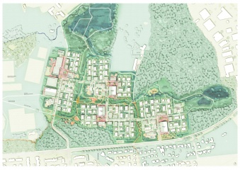
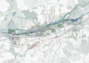
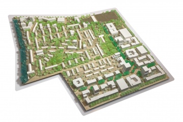
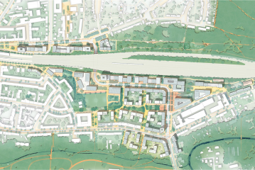
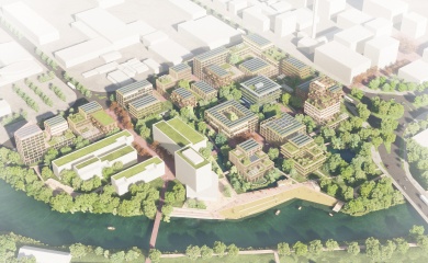
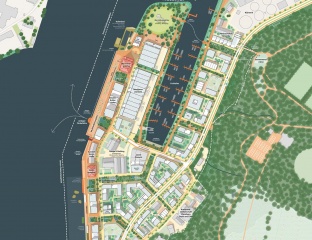
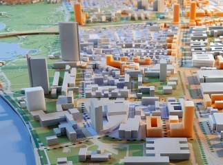
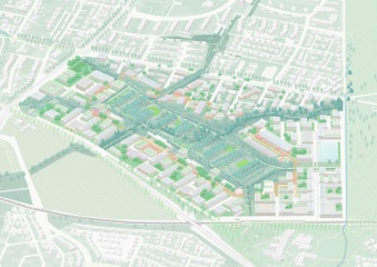
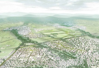
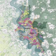
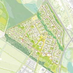
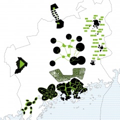
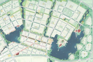
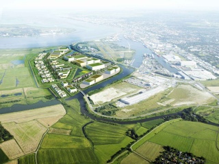
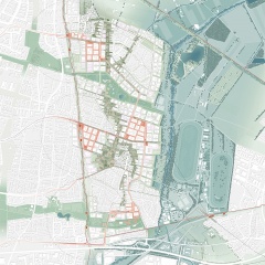
    In cooperation with the Dutch landscape architects Felixx, we created a design for the site of the old freight yard in Duisburg.

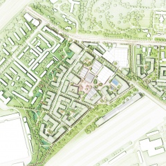
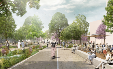
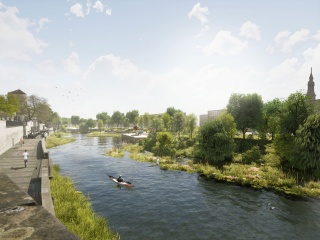
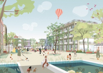
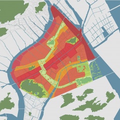
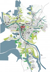
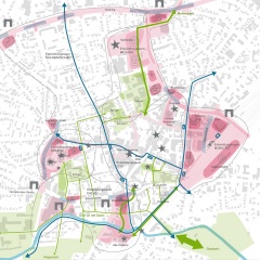
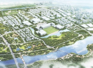
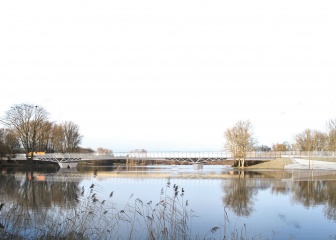
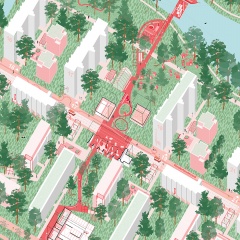
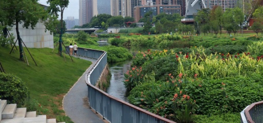
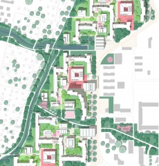
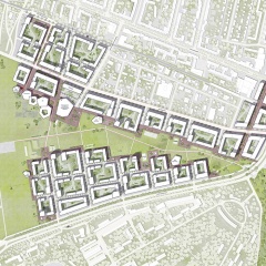
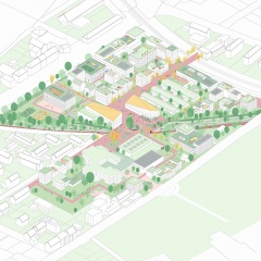
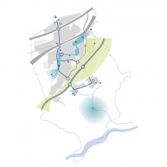
    The site is being freed from its island location and reclaimed as a piece of the city: The large Westpark acts as a magnet for all Duisburg residents and brings life to the quarter. An important component is the almost 14 hectares of open space that is used for a better climate, cleaner air, water management, biodiversity as well as sport, recreation, and community. In particular, local public transport and non-motorized traffic will be strengthened: five bridges (bike/foot) span the motorway and tracks and connect the largely car-free district with its neighborhoods.

    open space
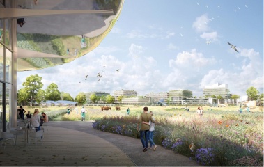
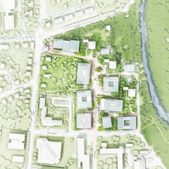
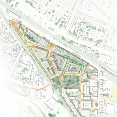
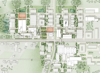
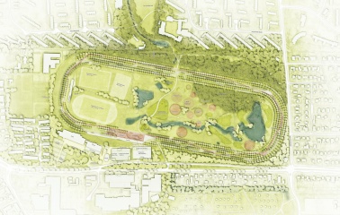
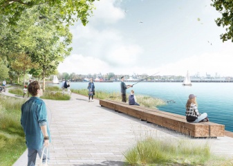
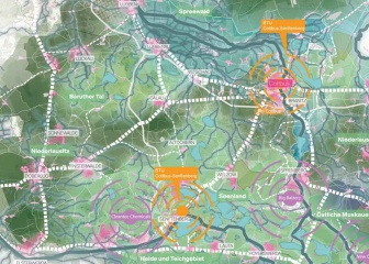
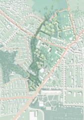
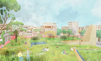
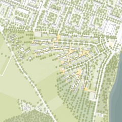
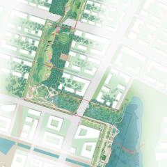
    The Westpark is designed as a spacious landscape park and, with a size of almost 14 hectares, offers space for all Duisburgers. A 12m high wall with a tree filter shields the noise and pollutants from the motorway. Different habitats and areas of use are created from north to south: meadow park, cultural park, sports park, water park, forest park. A central axis - the mile - links the quarter with the city in the north and the park in the south. In addition, all east-west connections are linked to the mile.

    program
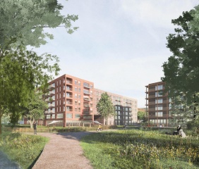
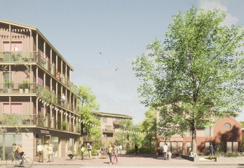
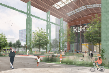
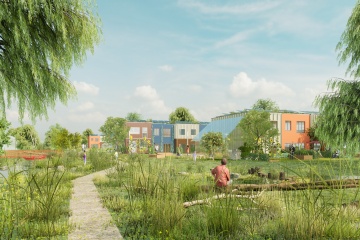
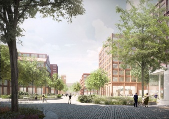
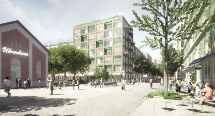
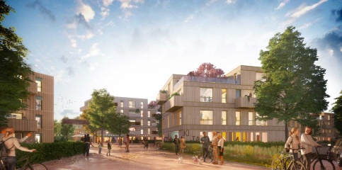
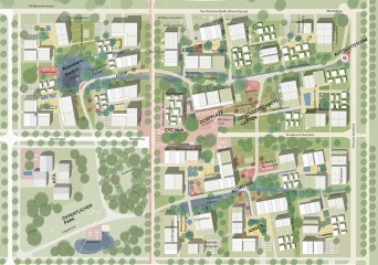
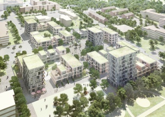
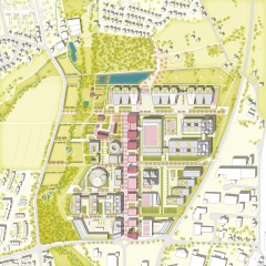
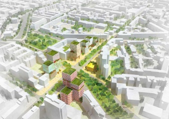
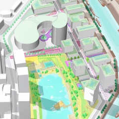
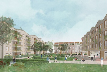
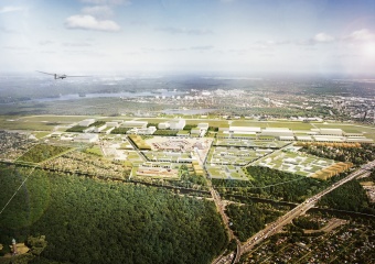
    The mixed-used quarter offers space for around 4,000 residents and 2,500 jobs thanks to various building types. The quiet residential areas each face the garden courtyard. In the north, there is the innovation quarter with offices, co-working, fab lab, start-up center, co-living, hotel, etc. Around the quarter square in the north, there are local suppliers, shops, cafes, market hall and market. An educational center is being built on Karl-Lehr-Straße with the "Karl 1", a house for movement + culture, as well as a library, VHS, music school, and elementary school with a daycare center at Westpark.

    Water, climate, energy
    The rainwater management works according to sponge city and cascade principles, in which rainwater is retained, temporarily stored, evaporated, and seeped away. The measures improve the microclimate (e.g. evaporative cooling, air purification), increase biodiversity, and the quality of urban space (recreational areas). Technical and near-natural measures of rainwater management are combined: These include blue-green roofs, infiltratable coverings, or various urban wetlands, i.e. retention and evaporation areas and plant-based cleaning systems. The energy system is organized on a decentralized basis and includes a heating, cooling, and electricity network, each of which is connected to the urban network. Roofs and facades are used to generate electricity and heat (photovoltaics).
    The west park is used to air-condition the quarter: Warm winds from the southwest (main wind direction) are cooled and filtered in the west park and guided into the depths of the quarter via the open east-west paths.

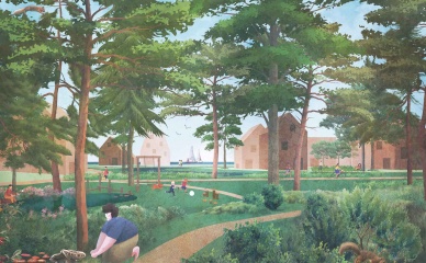
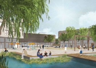
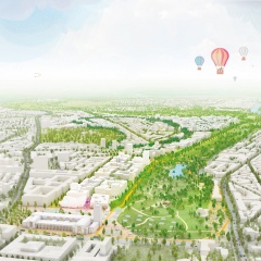
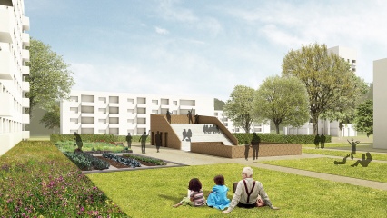
    Love Parade Memorial
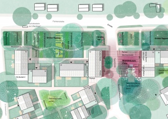
    The Love Parade memorial is to be integrated into the quarter. A place that has its place in people's everyday life. The memorial will be part of the planned park, a place of tranquility, and will also be located in the heart of the new quarter. There is also a memorial grove between the mile and the memorial.

    We are very happy about the strong voting results of the public vote and the high level of support and acceptance from the people of Duisburg.

    Idea
    2021
    Duisburg
    Germany
  • Cradle-to-Cradle Industrial Park

    The concept Cradle-to-Cradle (C2C, Michael Braungart et al.) is based upon the idea of a circular economy in which resources are not consumed but are continually used. The feasibility study explores how this concept can be transferred to the development of industrial parks: C2C-principles for the design of buildings, open spaces and infrastructure are developed and a structural plan for a test site in Bielefeld, Germany, is laid out.

    Moreover, an energy system for the whole area is designed and C2C-prototypes for buildings and open space situations. The approach of the study is holistic and interdisciplinary and its planning recommendations can be used for the development of new industrial areas as well as for the transformation of existing sites. The study is part of the INTERREG-IVB project „Cradle to Cradle Business Innovation & Improvement Zones. C2C-BIZZ". Please contact us for the entire feasibility study.

    completed
    2014
    Am Niedermeyers Feld
    33719 Bielefeld
    Germany
  • Lively skyscraper ensemble

    The city of Berlin is characterized by solitary peaks that build up little connection to each other. The skyscraper confetti thus forms the opposite position to the clearly defined perimeter block development. The design area, as a gateway to the densely populated area of the City West, brings the great potential of four related properties and their simultaneous development.

    A cluster of 2-3 high points will be formed on each plot, inspired by the diverse buildings in the surrounding area. The distribution of the building mass on different high points makes the buildings resilient and efficient since they can be divided and used differently. The concept is based on the continuation of the diverse and sophisticated urban structure while at the same time ensuring high land utilization. By emphasizing the intersection as an urban, high-density hotspot, a new location with special centrality and distinct urban conciseness is created.

    Idea
    2018
    Berlin
    Deutschland
  • District Landscape Dietenbach

    How does a newly developed city district become a vibrant place to live?

    The characterful landscape of Freiburg with the surrounding Schwarzwald serves as the decisive basis for the newly designed district Dietenbach. The four emerging quarters will be connected by a ring boulevard. In contrast to the generous open spaces, which serve as decelerated exercise and relaxation areas and make a significant contribution to nature and species protection, pulsating life takes place here. The new city centre serves as a bracing supply center and community reference point with symbolic centrality. In addition to the 5,500 residential units, new jobs and schools will be created in the 108-hectare area, which will complete the new living environment.

    Integration into the urban, functional, and landscape context
    The new district Dietenbach is structured by the iconic landscape, especially the eponymous Dietenbach.

    The resulting open spaces ensure the supply of fresh air and a stable microclimate. The former course of the Käserbach river has been reactivated and serves as partially communal garden land. In the region of ​​the school and sports campus, this zone also includes play, sports, and recreation areas that can be used by the public.

    In contrast to this, the new centre of the district as a communal supply center offers space for weekly markets, city festivals, outdoor areas for restaurants, and water features. There are also retail stores, gastronomic offers, and services. The building plots of the compact quarters address different market segments. A large number of construction site sizes, building heights, building types, and locations provides a large typology mix and thus offers a lot for different target groups.

    Mobility concept
    The mobility concept pursues the goal of reducing motor vehicle traffic, car ownership, and the number of parking spaces. This makes an important contribution to an attractive living environment, affordable living space, and environmentally friendly transport. It is achieved by creating attractive offers for pedestrian and bicycle traffic, public transport with light rail, as well as offers for car sharing and e-mobility, and also by parking in district garages in less sensitive locations that are up to 200m away from the apartments.


    completed
    2018
    79114 Freiburg im Breisgau
    Germany
  • Bergviertel Krampnitz, green I enlived I in motion

    Based on a strong landscape and valuable historical structures, Bergviertel Krampnitz is a forward-looking quarter, creating its own identity as a place to live and work in harmony with the environment. Against the background of a climate crisis and scarcity of resources, it will be sustainably developed and will serve as a centre of life for a broad cross-section of the population. A small-scale and diverse density creates a lively place, is gentle on resources, uses infrastructures efficiently and relies entirely on the mobility of the future - the environmental network.

    Small and large apartments in the same building ensure social diversity, intergenerational living connects young and old and assemblies along with community-oriented housing projects enable self-determined living. The combination of living and working responds to the trend to more strongly combine leisure and work as well as career and family. Strong and diverse open spaces, differently addressing the building plots, bind everything together and enable uses from communal gardening to sports and leisure activities up to generous landscape experiences.

    completed
    2021
    14476 Potsdam
    Deutschland
  • Innovation Valley Garzweiler

    Due to the planned coal phase-out by 2038 and thus the elimination of a complete industry with many jobs, strong visions of the future already need to be developed today. How can we reintegrate the gigantic areas that will soon be fallow again in a sustainable manner and make them usable?

    Located in the border triangle, our workshop was about developing a vision for the area in and around Garzweiler. The main goal here was to move away from the current linear to a circular economy. The starting point of the concept was the question of how we can draw a strong vision of the place that addresses its complex issues: What does innovation need? What will energy production look like in the future? How can we restore the immensely damaged ecosystem and reconnect the fragmented biotope network? And what do the municipalities and residents of the region need? How can all these aspects be thought of in a cycle and thus map a strong, sustainable system?

    To give answers to all of these questions, the concept provides for the creation of an innovation network from three well-developed commercial locations in Jüchen, Jackerath, and Frimmersdorf, which tie in with existing plans. The conversion of the Frimmersdorf power plant, which is otherwise to be demolished (planned paralysis in 2021), creates a supra-regional innovation hub and acts as a gateway to the region. Its huge pre-built areas serve as a playground for start-ups as well as established companies. The power plant is a visual reminder of the cultural heritage and the important past of the region, but on the other hand, shows the big step forward towards a sustainable future. The pioneering spirit that has prevailed for decades is being rethought and translated into 2035.

    Large contiguous recultivation areas for industrial agriculture feed electricity into the local grid through additional use for wind power and PV systems. We are creating ecological corridors (forestry recultivated, natural green structures), which in the future will span between the lakeshore and the forests of the Erft floodplain and, in addition to safeguarding the species network, also represent interesting areas for tourism. Thus the economic situation of the region is strengthened. They are lined with laboratory areas: small-scale fields and garden structures on which circular agriculture is researched, tested, and applied.

    Garzweiler is an attractive area, but how can villages be developed, and what offers need to be created? Resource-saving, water management, or new forms of mobility are just a selection of important topics and factors that need to be considered. We propose different lighthouse regions in which to settle. In this way, for example, the new town of Niers am See is created. With the inevitable flooding of the Garzweiler II opencast mine and the resulting lake the size of the Tegernsee, there is an extraordinary opportunity for the realization of a model city with decentralized rainwater management and close networking in the adjacent natural biotopes. As soon as the opencast mining is completed, the respective villages can grow to the edge of the former mine and then have their own waterfront promenades in the final state.

    The concept is rounded off by a cableway that links the various areas.

    in progress
    2020
    Jüchen, Rheinisches Revier
    Deutschland
  • Grand Standing. Urban Centre Berlin

    The building's structure is based on the static elements pillar, plate and gate as well as the every few minutes incoming trains. A natural passage from Luckernwalder street to the signal box and the park connection south is build up by the viaduct facades of lines U2 and S21. They could easily be activated by contemporary commercial usage for the traffic centre "Heart of Stations".

    In sum, a unique specimen is generated, creating a special atmosphere and spatial quality between the tracks and towards the park. In the north-south direction, the slender, 17-storey superstructure is extended over the property. It is adapted as a rostrum and stage to the park and fits into the heterogeneous property structure between ICE lines and stations. In the base area, four gates allow the train transits and significant visual references in north-south as well as in east-west direction. On the various levels, " heavenly" spaces for non-commercial transit and temporary users are integrated into the structure of established users and anchor tenants.

    completed
    Berlin
    Deutschland
  • Greater Helsinki Vision. Eight profiles, one unity

    'Holistic Uniqueness' proposes a future vision and a robust
    development framework for Greater Helsinki, Finland. The
    region is globally positioned as the interface between the EU and
    Russia. A high-velocity train network links Helsinki to the Baltic
    centres, Stockholm, Tallinn and St. Petersburg, establishing a
    transnational connection.

    The Greater Helsinki Region itself is defined as a configuration of eight core areas, each characterised
    by a unique programmatic and spatial profile. Based on
    the incorporation of global future developments (like energy
    shortage, demographic change etc.) and existing local potentials,
    the profiles act as concepts for sustainable development -
    ensuring global competence and creating local identity at the
    same time. A specific urban form and structure are proposed for
    each area, strengthening the programmatic profile and creating
    diverse relations between urban and green spaces. Within
    this metropolitan configuration, each area will offer something
    unique. Therefore they are linked not only by a sophisticated
    transport system but more importantly by complementation of
    each other.

    Idea
    2007
    Pohjoisesplanadi 11–13
    00170 Helsinki
    Finland
  • Unusual living KIDS

    In Germany, 90% of all children live in cities - 60% in large and medium-sized cities alone.

    The concept study takes this as an opportunity to redesign the existing housing estate on Bürgermeister-Reuter-Straße in Bremen Vahr according to the principles of a child-friendly city. The settlement shows various potentials in open space as well as in the building stock. In addition to the location on Lake Vahr, the rich tree population and the generous open spaces, the sealed parking spaces, the repetitive, underused open spaces, and the missing center pose challenges.

    In phase 0, a footbridge will be built that connects the neighborhoods with each other and interweaves the settlement with the network of paths in the area. It creates a center for the entire quarter, creates an address on Kurt-Schumacher-Allee, invites you to the quarter, and leads to the water. This is where people play, romp, rest, chat, celebrate, cook - a meeting point and link between the neighborhoods.

    The redensification strategy is subordinate to the maintenance of the valuable tree population and is divided into measures of upgrading, increasing, and adding. New forms of living promote the social mix in the neighborhood and enable new, diverse family structures and forms of living together in the long term.

    A central neighborhood garage on the main street, supplemented with decentralized mobile stations, enables a car-free neighborhood - this increases security, which at the same time brings more space to play on the street.

    The open space is made usable in the form of private gardens, neighborhood islands, playgrounds, and the "children's wilderness". The footbridge offers various areas of play - also for informal play and nature experiences.

    In the climate-neutral quarter, the roofs are activated as blue-green solar roofs. The rainwater is collected, stored, and evaporated. Biodiversity is promoted and made visible through bee pastures, hedges, and orchards. The footbridge leads as a research path through the future-oriented quarter. There, children can play close to nature and explore relationships between themselves and their environment. Sustainable use of resources can be learned in childhood.

    Idea
    2020
    Bremen
    Germany
  • Sponge City Hefei: Five landscapes - one park.

    When a park becomes an adventure.

    Building on the master plan for the Sponge City Hefei, we next looked at one of its four large parks. The resulting profile should serve as a sample plan for the remaining zones.

    In the centre of the park, which is divided into five different areas, is the river, which is integrated as a characteristic element of the Sponge City and is of central importance. It acts as a catch basin for precipitation and floods of all kinds and thus contributes to sustainable urban development.

    Depending on the weather and the season, the park looks different and seems to be reinventing itself again and again. If the water coming from both sides of the city causes the river to swell, the park becomes, for example, standing water.

    The many plants and trees that form an entire forest in some areas are a central element of the park itself. In some parts, like the eco shore, the existing vegetation is even integrated and made tangible. In addition to the resulting shade donating places and high natural biodiversity, there is another climate-active aspect: The trees store the water at night, which they release into the air in droplets during the day, thereby helping to lower the temperature.

    While on the one hand areas are designed for meetings and events with large sunroofs for a market, for example, there are several leisure options along the spacious boulevard of the urban waterfront. There happen to be boat moorings, an amphitheatre in the water, a variety of cafes, or a specially planned swimming pool. The wetland, however, represents a completely different type of landscape design. In addition to areas with retention basins that function in a similar way, the water slowly seeps away, thereby relieving the sewage system.

    In order to make the use of a bicycle instead of the car more palatable, a cycle expressway from north to south was planned and cross-paths ensure that the eastern and western residential areas are connected.

    The variety of designed different areas answers every aspect and every question that public space can fulfil.

    For more information, we highly recommend our video about the project on CFTV.

    in progress
    Hefei / Anhui, China
    China
  • Sponge City Hefei

    What does sustainable urban development with a special focus on the sponge city principle in China look like?

    The flagship project Sponge City Hefei relies entirely on decentralized drainage, which should lead to an answer to the flood problem and the extreme weather events that will become increasingly stronger in the future. Our focus was on the planned parks as central and profiling elements of the city, which will become the "green living room" of future residents.

    With low-threshold and barrier-free access, the offers of the residential neighbourhoods are supplemented here and the informal meeting, which is so far untypical for China, is promoted. This is achieved through the targeted use of, for example, generous seat edges, freely movable furniture, and picnic areas.

    With the aim of creating a metropolis with a low climatic footprint and a small impact on local ecosystems, four large parks with large unsealed areas are being created. The special sponge city principle provides for working with instead of against the water and implementing it as a characteristic element of Hefei. This helps the green-blue city to regulate the climate - especially in the very hot summer months. In addition to the climatic advantages mentioned, our argumentation of integrating the local river, which was originally supposed to be led around the city, creates a number of added values ​​for Hefei.

    The four emerging parks will each have their own characteristics, depending on the respective demarcation area. For example, the ground in the west with many adjoining office buildings serves primarily as a place to relax during work breaks on the one hand and as an extended conference room with options for flexible work on the other.

    The project, besides providing spatial qualities and creating urban spaces that promote
    social interaction in cultural life aims to serve as an innovative hydrological system to protect the city in the event of more extreme weather occurrences and to ensure sustainable urban development.

    As a result of all the interlocking concepts, Hefei forms a richly linked city with different biotopes and parks that work together with the social infrastructure and create a high-quality living space for the new China.

    Take a look at how we continued by planning the first park here.

    in progress
    Hefei / Anhui
    China
  • Revitalizing Guitanghe

    The river Guitanghe in its current state holds complex problems for the urban development of Changsha. In the future, it is to be identified as a central and living lifeline in the city and its ecological, urban, social and cultural significance will be considerably increased.


    Based on a flood problem and different water levels of the Guitanghe, dynamic urban development is created that considers water as a variable in dimensioning and programming of spaces. In this urban experimental field, innovative economic and urban development concepts intermesh. Changsha, a growing city, gets an ambitious, positive and future-oriented perspective.


    The river is going to play a major role as the central and linear centre of the city and, in addition to water management measures, offers the opportunity to make urban improvements and to connect Changsha via green and blue veins emanating from the river, both within the city and outwards. The Guitanghe will work as a green lung and strengthen the urban ecosystem as well as it will provide the city of Changsha with a new identity through local recreation areas and social and cultural infrastructure.

    completed
    2019
    Changsha
    China
  • Cross-over

    At the junction between the media harbour area and the economical harbour area, a vibrant district is created, which has the interlacement of space, atmosphere and program as its principle. An encounter place for working, researching, inventing and recovering with a strong connection to the water arises. Two differentiated loops form the basic open-space framework. Central is the entirely experienceable loop of the leisure harbour with the urban city beach, green terraces, rowing club, marina and the "Kesselplatz" - square at the top of the peninsula.

    Future-oriented is also the industrial harbour, which fits like a second cycle in the system, as the industrial world 4.0 changes. Both "ports" get their new head-end structure through the Pier-One. The loops are connected via 6 public spaces, so-called braces, which pave the way for three squares - Kesselplatz, Hafenplatz and city beach - creating customized meeting places for visitors and residents equally. The urban structure is also characterised by the intermeshing of typologies and promotes innovation, creative work and vibrancy. This "striking harbour mixture" with towers, halls and bars forms the identity-creating and highly flexible structure for a vivid and multifunctional quarter.

    Idea
    2019
    40221 Düsseldorf
    Deutschland
  • Von Bergedorf zu BergeDörfern

    Bergedorf West is confronted with the typical challenges of a 1950s / 1960s housing estate: Few used open spaces, monotonous building structures without centers and orientation points as well as an insufficient structure for foot and bicycle traffic.

    In order to make Bergedorf fit for the future, the housing estate is being restructured and programmatically mixed up. Two open space bands - 1x "stream band", 1x "tree band" - structure the settlement structure in an east-west direction: "Bergedorf becomes mountain villages. New innovative building types enrich the three emerging subspaces. They increase the mix of use and housing, strengthen neighborhood life through public and communal first floors and create lively meeting places within the three neighborhoods. The structuring open space bands connect the three mountain villages, offer sports and recreation facilities and at the same time provide air conditioning, rainwater management and strengthen biodiversity.

    Idea
    2019
    21033 Hamburg
    Deutschland
  • Tannenberg Quartier

    The Tannenberg quarter is characterised by a distinct build framework that forms a clear centre and protects the quarter from traffic noise. An independent ensemble.

    The entrances and views of the quarter integrate into the existing context. The network of paths creates several links to the allotment gardens and the neighbourhood to the west: The Gumbinnenweg with its prominent row of trees becomes the main link for pedestrian and bicycle traffic. Private gardens and surrounding garden paths form connecting transitions to the private gardens of the neighbouring residential buildings and the allotment gardens (Klönschnack am Zaun).

    The generous open spaces with dense tree population ("grove") and the various garden areas have a significant influence on the character of the quarter: this is where you live "garden green".

    Idea
    2020
    Bremen
  • Kurt-Schumacher-Quarter "Open Wild Tegel"

    The impressive wide heath landscape of Tegel forms the identity-creating heart of the new district. It is "wide, open, wild and free". This landscape is shaped by a vivid seam, that maximizes the contact surface to the landscape. Schools, kindergardens and public squares activate this space. Here one can play, learn, rest and socialize. A variety of building typologies characterizes the district and offers a great diversity of programs. Residential buildings increase towards the seam, while offices and retail are more likely to be found at the well accessible edges. In Tegel one can find bigger and smaller buildings with panoramic views or gardens, intimacy or openness.

    Idea
    2016
    Kurt-Schumacher-Damm 38
    13405 Berlin
    Deutschland
  • Perspektivplan. Spatial Vision Freiburg

    Freiburg is a growing city where more and more people want to live. How can the city continue to be developed in a sustainable way? The Perspectivplan elaborates spatial development options for the City of Freiburg in the next 10 to 15 years. In the course of designing, built-up areas and open spaces are conceived and developed together. Based on a differentiated (GIS)-structure analysis, so far undetected potentials are made visible, development strategies are pointed out and by means of scenarios a future spatial image with a complementary structure plan is generated. The project has been developed in a cooperative process with stakeholders, the municipality, politics and the public.

    www.perspektivplan-freiburg.de

    completed
    2017
    Berliner Allee 1
    79114 Freiburg im Breisgau
    Germany
  • Seelze South, Landschaf(f)t Stadt

    Seelze Süd is characterized by strong references to open and clearly defined urban spaces. The quarter, which has been sustainably developed on the background of the climate crisis and resource scarcity, mediates between the existing settlement structure, trimodal western traffic axis, and open landscape. One of the outstanding features: 80% of the building blocks have a direct view on fields, forests, or areas of high quality in terms of nature conservation.

    In an exciting contrast to the wide landscape, the urban center stands as a mediating element to the existing settlement structure and as an entrance to the quarter. In direct contact with the water, there is a quarter square, retail, a health and a daycare center, a playground, co-working spaces, and student and assisted living.

    Development
    A settlement structure that is closely interlinked with the landscape is central to the new quarter. The building structure is consistently aligned with the open landscape and thus pulls it deep into the inside. In order to conserve the valuable resource soil, the areas to be built on are kept small and provided with a relatively high density. Economic development is thus guaranteed. If the roof surfaces are not used as terraces or gardens, they are used to generate energy and are intensely greened to promote biodiversity, microclimate, and rainwater retention.

    Free spaces
    Three large landscape pockets are programmed in a variety of ways: from an idyllic butterfly meadow to a small lake with a sandy beach to a BMX track, there is nothing left to be desired. At the entrance, there is also the important quarter square as a meeting point.

    Noise protection
    In order to provide protection from the 65 dB (A) expected in the north-eastern area at night, a largely closed development is used in the north and east. The chosen U-shape enables the creation of well-protected inner courtyards, which are intended for outdoor living areas. In addition, the general arrangement of the buildings enables additional noise shielding.

    Idea
    30926 Seelze
    Deutschland
  • Campus as Quarter

    The new quarter campus forms a high-quality central urban hub between the western and southern part of the city, which, through systematic revitalization and redensification, will sustainably supplement Heidelberg's educational landscape. The aim is to link the leisure and educational facilities and to expand the programme with living, working and public services to create a diversified and vibrant neighbourhood. The green open space strip, including valuable biotope structures and a north-south connection geared towards local mobility, connects the quarter to its surroundings. Superordinate development principles focus on the long-term maintenance of the livelihood of future generations and will create integrated and lively learning and living spaces.

    "Education happens everywhere - in the family, with peers, in leisure time and at school. Parents, school, day structures, associations - they all contribute to a holistic education." (Bildungslandschaft Schweiz)

    Idea
    2019
    Heidelberg
    Deutschland
  • Lune Delta°... designed as closed-loop cycles

    Taking into account the Cradle to Cradle philosophy, the Lune Delta forms an economic structure that provides design, ecological and social contribution even after the end of its period of use. The sustainable commercial area is based on the following principles: 1. integral: The structure fits into existing overall structures, arises and also benefits from them. 2. demand-oriented: Different requirements are covered by the initial cluster. The system of ditches forms its own ecosystem and areas for Commons are implemented. 3. diverse: Open space systems and the special sector mix resolve the contradiction between commercial use and landscape and contribute to creative and social diversity. 4.circular: Buildings, open space and infrastructures operate as material cycles. They support technical or biosphere principles and adapt functionally and in design. 5. sustainable: The use of renewable energies is a hybrid system, which is locally, infrastructurally and formally connected. 6. orchestated: The cooperative Development Company Lune-Delta controls processes, ensures synergies and promotes communication.

    in progress
    2017
    Luneplate
    27572 Bremerhaven
    Deutschland
  • Perspective Holzwickede

    For the growing city of Holzwickede, a long-term development concept is elaborated. The brief was a model for the overall city area and the definition of several urban development zones, with will be the focus of future city development. The recommondations for action are further concretized and located in a planning framework.

    The strategic project process starts off with spatial, social and historical analysis, then describes area profiles and development goals and strategies. Zoom-ins of the focus zones show more contrete provisions and exemplified spatial strategies.

    On the basis of the integrated action plan and the strategic development chances, processes can be verified, evaluated and arranged in the future, such as individual actions can be derived.
    The integrateted action plan is accompanied by a civic activism process and cooperation with the local goverment.

    completed
    2016
    59439 Holzwickede
    Deutschland
  • TXL Restart. Integral Systems

    The airport Berlin Tegel is going to be closed down. TXL will be developed as a high-quality research, industry and business park with the profile of 'urban technologies'. A strategic master plan builds the foundation for a flexible - and therefore, robust - planning process. Developmental guidelines and a profound system of rules create a structural, programmatic and creative quality of strategic important subareas.

    Simultaneously, more flexible developmental options are being allocated for other areas. ‚Quarters' profiles' emphasize existing potentials of subareas and strengthen the specific identity. An integrated concept for energy and water supports sustainable development: biomass, geothermal energy, wind energy and photovoltaics provide regionally generated energy. Gray and rainwater is being collected, refined and reused regionally. An urban aerial railway connects the site with the station and the tram. Here, the aerial railway is not only an efficient, sustainable means of transport but also represents sustainable mobility in terms of the site's profile.

    completed
    2012
    Saatwinkler Damm 62
    13627 Berlin Tegel
    Germany
  • Unfold Rosenstein

    The project completes Stuttgarts inner city. Like a mosaic, three new quarters fit into the existing situation and create an extension of the district with a strong and individual character. The three new quarters refer structurally to their surroundings and create together with their own „centres" strong identities. The common „urbangreen ribbon" connects the inner part of the city with the surrounding and creates a mutual meetingspace. By doing so the barrier of the track curve can be dismantled and transferred into a new central open space concept with an inner green lung. In the new eastern district-seam, the historical park meets mediating landscape, various leisure offers and finally the new district. A central key in the Rosenstein mosaic are the large school campuses, which act as joints between the new quarters and merge the open-space „seam" with the „urban green ribbon". In this way the project is embedded in Stuttgarts large-scale green system and is at the same time strengthening the connection to the Neckar, to Bad Cannstatt and the whole city of Stuttgart.

    Idea
    2018
    Stuttgart
    Deutschland
  • Øresund Region 2040

    The project is based on three aspects: 1. future megatrends, 2. strengthening a sustainable society via social equality, healthy environment, and qualitative economic growth, 3. participation along with reflective, visionary guidance as the basis for effective and flexible developments. High-velocity train and ferry connections will enhance the position of the Øresund Region as an interface between Central, Northern and Baltic Europe.

    The development concept for the Øresund Region itself combines two main structures: the Metrosund, an association of nine cities encircling the Sund, and the Ørezones, nine sub-regional areas. Each Metrosund-City and Ørezone is given a unique profile based on existing characteristics and demands of the aforementioned megatrends, generating regional identity and global competence. Within the hinterland networks of SMESTOs (Small and MEdium sized TOwns) give a flavour of the local qualities. One key agency will guide the development process: Øresund Visionary Guidance, a multidisciplinary, independent, cross-border task force working closely with the people of the Øresund Region.

    Idea
    2007-2008
    Lufthavnsboulevarden 6
    2770
    Denmark, Sweden
  • Munich North-East

    How can strong urban growth be reconciled with village structures? A question that is becoming more and more important nowadays.

    In Munich Northeast we orientated our plan to the existing villages, meaning that along the existing and future infrastructures (S-Bahn + U-Bahn) new dense, urban, and mixed-use quarters are growing, which structure the space. In this way, a district for 30,000 residents blends smoothly into its surroundings.

    A village and its church. Hybrid multi-story buildings in a mosaic of squares, gardens, and fields. A water landscape with an alpine view. Mutual references and soft transitions facilitate the emergence of diversity and a mixed city of diverse actors. A field of tension between anonymity and community, between central S-Bahn and historic village square, between the world of work and the field.

    Idea
    2019
    81929 München
    Deutschland
  • Updating Nordweststadt

    Like many other residential schemes of the 1960s the Nordweststadt in Frankfurt requires an update of its building stock, a redesign that meets current and future demands of urban living. A set of transferable, integrative, and low-cost design measures is developed, focusing on three main tasks: Tidying up, the regeneration of neighbourhoods, and the strengthening of identity.

    Shrubs and trees are cut back, the parking is reorganized, pedestrian and cycle lanes are being introduced, new public spaces are designed and the courtyards are upgraded by private gardens, new public green amenity spaces and 'light pergolas' - a minimal architecture that connects basement parking with the courtyards and passes over into a podium with seating steps on ground level. The light pergolas enclose a small lounge, an external barbecue, water and electricity connections and a bicycle workshop. During evening hours and at night the pergolas illuminate the courtyard, by day these enable diverse and easy use of the courtyard and strengthen a lively community.

    completed
    2010-2014
    Gerhart-Hauptmann-Ring
    60439 Frankfurt on the Main
    Germany
  • Yueyang. Better water - better city

    Yueyang is a growing city in the Chinese province of Hunan. In cooperation with hydrology, water management, and water ecology experts as well as landscape architects, we developed a masterplan with the aim of a new adjustment of urban and open space development in the course of water quality improvement.

    The masterplan analyses the spatial and programmatic potentials of the Nanhu (lake) and the surrounding build-up and open space structures and develops them as a blue-green infrastructure. That improves the city's interconnectedness and the accessibility of green spaces. A catalogue of sponge city strategies proposes transferable concepts for a structure related integration of sponge city principles. The blue-green-black masterplan merges the strategies and delivers design approaches for different types of waterfronts and city profiles.

    completed
    2016
    602 Dongting S Rd, Yueyanglou Qu, Yueyang Shi, Hunan Sheng, China
    414000 Yueyang, Hunan
    China